
NASA Research Announcement NRA-98-OES-13
Title: ERS-SAR Data Consortium: Western North America Tectonics
Principal Investigator:
David T. Sandwell, Professor of GeophysicsDepartment:
Scripps Institution of Oceanography, Inst. of Geophysics and Planetary PhysicsInstitution name:
University of California, San DiegoStreet/PO Box:
9500 Gilman DriveCity:
La Jolla State: CA Zip: 92093-0225 Country: USAemail:
dsandwell@ucsd.edu Telephone: 619-534-7109 Fax: 619-534-2902Co-Investigator(s):Name Institution Telephone email
Yehuda Bock, University of California, San Diego. 619-534-5292,
ybock@ucsd.eduBernard Minster, University of California, San Diego, 619-534-5650, jbminster@ucsd.edu
__________________________________________________________________________
Requested Starting Date
July 1, 1999 Type of Institution: EducationalBudget:
Year 1: $120,170 Year 2: $107,890 Total: $228,060Other organizations to which this effort has been proposed:
NSF
Certification of Compliance with Applicable Executive Orders and U.S. Code
By submitting the proposal identified in this Cover Sheet/Proposal Summary in response to this Research Announcement, the Authorizing Official of the proposing institution (or the individual proposer if there is no proposing institution) as identified below:
Willful provision of false information in this proposal and/or its supporting documents, or in reports required under an ensuing award, is a criminal offense (U.S. Code, Title 18, Section 1001).
Title of Authorizing Institutional Official: __________________________________________
Signature: Date:
Name of Proposing Institution:
Telephone: E-mail: Facsimile:
NASA Research Announcement NRA-98-OES-13
Title: ERS-SAR Data Consortium: Western North America Tectonics
Principal Investigator: David T. Sandwell
Budget:
Year 1: $120,170 Year 2: $107,890 Total: $228,060Program Area: See Appendix A of NRA for details. Check no more than 2
I. Dynamics of the Solid Earth
1. Static and Time Variable Gravity Studies _________
2. Earth Orientation, Reference Frames, Angular Momentum _________
3. Geomagnetism _________
II. Topography & Surface Change
1. GPS and INSAR Applications ___Ã_____
2. Global Sea Level Change _________
3. Coastal Hazards _________
4. Flood Disaster Management Applications _________
5. Landslides _________
6. SRTM/Topography and Surface Change _________
III. Hazardous Consequences of Climate Variability _________
IV. Thermal and Geothermal Hazards
1. Wildfires _________
2. Volcanic Hazards _________
V. Pacific Disaster Center _________
VI. Geologic Applications of Remote Sensing _________
VII. Airborne Data Acquisitions/Pacific Rim Campaign _________
Proposal Summary (Single spaced), objectives and justification, prior accomplishments, proposed work and methodology.
Interferometric SAR (InSAR) has become a powerful tool for mapping the small-scale (0.1 km to 50 km) strain patterns that may be spatially aliased by the comparatively coarse GPS array. Several groups have used, or will propose to use, ERS SAR data to monitor crustal strain over broad areas. Currently the Southern/Central California ERS archive extends from 1992 to the present. To make the best use of these data at the lowest cost to the US funding agencies, we have formed a consortium of 13 institutions. This proposal is to fund the purchase of the newly acquired data for the Consortium. The European Space Agency (ESA), and the two companies with copyrights to the North American data, Eurimage and SpotImage, have approved the shared use of the data within a pre-defined group. Currently, the shared archive consists of over 100 frames of raw ERS SAR data on a tape/disk archive computer (arch.ucsd.edu). Here we propose to update the archive with new SAR data collected by an X-band downlink facility at SIO (>400 frames/yr). The advantages of direct reception are; slightly lower cost, near real time access (hours instead of 4-6 weeks) and larger ground mask extending into Mexico. This proposal covers a part of the data costs only; the operating costs of the facility will be covered by the State of California, NASA-EOS, the US Navy, and NOAA.
1. & 2. RESEARCH OBJECTIVES AND RELEVANCE OF PROPOSED WORK
Over the past several months, we have organized a group of investigators who have expressed interest in the purchase of ERS SAR data from Western North America and especially along the North American Pacific Plate Boundary. Until recently, ESA provided limited supplies of raw SAR data to most researchers through their AO process. As data usage increased and InSAR processing became more routine, the data demands far exceeded ESA’s capabilities to provide free data. Many of the research requests for AO-03 were not approved by ESA, especially those of new investigators. Moreover, ESA is under pressure to make their satellite and ground operations self supporting. This proposal serves multiple purposes:
Institutions and Users
1. California Institute of Technology - Mark Simons (simons@gps.caltech.edu)
2. Cornell University - Bryan Isacks (
bli1@cornell.edu)3. Jet Propulsion Laboratory
Ron Blom (rblom@mail1.jpl.nasa.gov)
David Curkendall (David.W.Curkendall@jpl.nasa.gov)
Diane Evans (diane.l.evans@jpl.nasa.gov)
Eric Fielding (Eric.Fielding@earth.ox.ac.uk; ericf@kahn.jpl.nasa.gov)
Michael Kobrick (michael.kobrick@jpl.nasa.gov)
Gilles Peltzer (gilles@altyn.jpl.nasa.gov)
Paul Rosen (Paul.Rosen@jpl.nasa.gov)
Frank Webb (fhw@cobra.jpl.nasa.gov)
Charles Werner (cw@vega.jpl.nasa.gov)
4. Scripps Institution of Oceanography
Duncan Agnew (dagnew@ucsd.edu)
Yehuda Bock (ybock@ucsd.edu)
Bernard Minster (jbminster@ucsd.edu)
David Sandwell (sandwell@radar.ucsd.edu)
Hadley Johnson (johnson@ramsden.ucsd.edu)
Suzanne Lyons (slyons@ucsd.edu)
Rosanne Nikolaidis (rosanne@ucsd.edu)
Evelyn Price (evelyn@magellan.ucsd.edu)
Karen Watson (kwatson@pgga.ucsd.edu)
Frank Wyatt (wyatt@ramsden.ucsd.edu)
Simon Williams (
simon@pgga.ucsd.edu)5. Stanford University - Howard Zebker (zebker@jakey.stanford.edu)
6. University of California Berkeley - Roland Bürgmann (
burgmann@seismo.berkeley.edu)7. University of California, Los Angeles — Paul Earle (pearle@ucla.edu)
8. University of Colorado - John Rundle (rundle@terra.colorado.edu)
9. University of Hawaii
Mike Bevis (bevis@soest.hawaii.edu)
Peter Mouginis-Mark (pmm@kahana.pgd.hawaii.edu)
10. University of Miami, Rosenstial School of Marine and Atmospheric Science
Tim Dixon (
tim@corsica.rsmas.miami.edu)11. University of Memphis
Mike Ellis (ellis@ceri.memphis.edu)
Alex Densmore (
densmora@tcd.ie)
12. University of Texas, Center for Space Research
Melba Crawford (crawford@csr.utexas.edu)
Steve Nerem (snerem@santafe.gsfc.nasa.gov)
Bryon Tapley (tapley@utcsr.ae.utexas.edu)
Sean Buckley (
buckley@csr.utexas.edu)13. U.S. Geological Survey
Ken Hudnut (hudnut@seismo.gps.caltech.edu)
Wayne Thatcher (
thatcher@thepub.wr.usgs.gov)One may ask why the consortium is limited to this special group of investigators. Ideally there would be free and open access to all earth science data but the reality is that the companies with the rights to the sale of the North American data want to maximize their return on their investment. Through negotiations with ESA, SpotImage, and Eurimage, we have compromised on a group of 13 institutions that can have access to the purchased data (i.e., ERS-SAR Data Consortium). Each institution will agree to abide by the terms of the purchase agreement, have a representative to keep track of data purchases, and provide a "wish list" for the data buys. This person will distribute data to interested research users in his/her institution and be sure that they not knowingly disclose the data beyond the institution. Whether or not this proposal is funded, it is important to maintain this concept of a group purchase. An alternate group-purchase model would be for each investigator to co-ordinate their data purchases through the consortium so data are not purchased multiple times.
3. & 4. EXPECTED RESULTS AND DETAILED WORK PLAN
Real-Time Access
To avoid issues of proprietary data, we propose that all data will be available on-line at all times to members of the Consortium. Section (7) describes the funding and operation of the X-band downlink facility at SIO. Here is how we envision the facility will operate:
i) The Consortium will place a standing order with ESA to have the ERS-2 radar turned on over the desired areas. Gilles Peltzer has already defined the most critical areas and the ERS archive is extensive in these areas (Figure 1). There are about 40 frames in this list and 10 repeat cycles per year so the baseline acquisition is ~400 frames/yr. (It should be noted that we must schedule and pay for a minimum of 2 consecutive frames per track requested although the satellite is typically turned for a much longer period.)
ii) The schedule is entered in the TeraScan software and the tracking system acquires the data and places it on a RAID disk. Note that in cases of a system failure, the data are also being downlinked at the ESA station Prince Albert, Canada when the satellite is within their mask. Data acquisitions will occur at about 10:30 AM local time approximately 13 times per month. Each acquisition lasts about a minute.
iii) The level 0 (5-bit) data are converted into the standard raw CCRS format and copied to a holding area on (raidsat.ucsd.edu). In addition a minimal ASCII header is constructed for the pass; it provides the essential information needed for the Stanford/JPL SAR processor. The satellite position and velocity at the start and end of the pass will be based on highly accurate (30 cm), predicted ephemeris from the Delft University (
Figure 1. Frames of ERS-2 SAR data that are routinely collected by ESA at the Prince Albert station. Gilles Peltzer has requested these data acquisitions since 1992 so the ERS data archive is rather complete in these areas. These 40 frames are collected each repeat cycle (35 days).
iv) The raw data file and header file will be checked, copied onto the IGPP Mass Store, and placed in the appropriate track directory. Before the next acquisition, the data will also be copied to DLT tape and then the files will be deleted. This activity requires a part-time data manager.
v) Users will have ftp access to the mass store (arch.ucsd.edu) where data transfer rates are typically less than 20 Mbps. For slower links or large transfers exabyte or DLT tapes can be used. We have mailed for than 100 tapes of global gravity and topography data with no charge to the user if they send a tape with a return envelope.
vi) In case the overall system fails or the consortium members are not happy with the results, the direct downlink mode can abandoned and the consortium can change to a system where ESA acquires the data and mails out tapes; in either case, the contract with Eurimage or SpotImage is on a monthly basis and they have provided quotes for each type of service. For the direct readout option, SIO takes most of the burden and incurs most of the risk while the users have potentially faster access as well as a fail safe backup acquisition system for data acquired north of the Mexican border.
Planning New Acquisitions
The objective is to maintain flexibility for the consortium members while sticking to a rigid routine for the direct data acquisitions. Each institution should have a representative to keep track of acquisitions (and purchases of archive data) and provide a "wish list" for scheduling the acquisitions. Usually the wish list will be sent by e-mail to the archivist but, in addition, at least once per year the Consortium should meet to discuss possible changes to the acquisition schedule; we propose that this meeting occur at the Fall AGU Meeting. The representative from each institution will distribute new and archive data to interested research users in his/her institution.
We propose to maintain the "baseline acquisition" schedule developed by Gilles Peltzer (Figure 1) although the acquisitions will be modified (based on user requests) and acquisitions could be expanded with infusion of more funds. Individuals of the consortium will have three ways to obtain the data they need. First they can purchase data from ESA (probably older data) using their own funds as part of the consortium deal. We hope that these data are inserted into the common archive or made accessible to other members in some way but at least the member should inform the archivist of the acquisition so the consortium data base can be updated. The second approach is to obtain additional funding to expand the area. This additional coverage could be for ascending passes as well as for some data from outside of the Prince Albert mask. The third approach is to simply wait until the newly acquired data reach the temporary disk or the archive. In each case, the data that are copied from a UCSD disk should be signed out and we will report this usage to Eurimage or SpotImage on a monthly basis. Currently the archivist is Karen Watson (kwatson@ucsd.edu).
Funding for Operations
The weakness of this proposal is that while we have a simple operations plan, we do not have complete funding for the operations. We have not included the operations costs in this proposal because it would increase the per frame data cost above the standard ESA purchase price. We estimate that a data/computer manager working half time could operate the facility, archive the data and maintain the web-based lists. Maintenance of the hardware will be done on a case-by-case basis. All of the RF electronics was installed by a UCSD electrical technician (Tony Hodgins) and he is on call for repairs with a typical response time of one day. Our SIO machine shop has repaired many problems on the 18-year-old satellite dish. They perform lubrications at 6-month intervals, and they have a good knowledge of the mechanical components. These local services are funded on a case-by-case basis either by the SIO Director’s office or an account derived from donations from petroleum exploration companies. Under a separate grant from NASA (Earth Remote Sensing Center of Excellence at Scripps Institution of Oceanography- PI, Greg Mitchell, SIO) we have funds to upgrade the X-band digital electronics to capture the high data rate link from EOS-AM1 for acquisition of full resolution of MODIS data. In addition this Centers of Excellence funding provided a suite of computer components that now reside at the X-band downlink facility; this facility also serves as a remote sensing classroom. A second NASA grant (HPCC/ESS — Advanced Computing Technology Applications to SAR Interferometry and Imaging Science — PI, David W Curkendall, JPL) provided the funds for high speed network communications from the X-band downlink facility to the San Diego Super Computer Center. The objective of this work is to send the real-time data stream (105 Mbps) to JPL for real-time processing on their super computer. This network upgrade will also ensure good ftp access for Consortium users. The IGPP Mass Store was mostly funded by NSF although, soon the X-band facility will have to contribute approximately $10K/yr. to the operations costs. Finally, the State of California has established a remote sensing initiative with significant new funding for UC Campuses. The SIO X-band facility is a cornerstone of that initiative and it will receive significant funding for operations if the State initiative is approved.
5. ROLE OF PI, CO-I, COLLABORATORS AND OTHER PERSONNEL
David Sandwell directs the operations of the facility and works with SeaSpace engineers to fix bugs and enhance capabilities. Kota Prasad (SeaSpace Co.) is in charge of the overall development of the X-band system and manages the NASA SBIR contract. Bernard Minster and Yehuda Bock collaborate on all scientific aspects of the facility. They also provide geodetic expertise and also some additional funding from other sources. The Consortium members define the acquisition schedule. Karen Watson (graduate student) maintains the data archives and web pages (
http://lox.ucsd.edu/~kwatson/SARdata.html) for the Consortium. Paul Henkart maintains the IGPP Mass Store. Chen Xi (graduate student) has his office at the X-band facility and watches the signal from every pass of ERS-2 and Radarsat to detect problems with the RF and mechanical components.6. DATA REQUIREMENTS — See section on DETAILED WORK PLAN
7. SUPPORTING FACILITIES
With funding from a NASA (SBIR) grant (50%), the State of California (25%) and internal funds (25%), SeaSpace Corporation and Scripps Institution of Oceanography have developed an X-band satellite data acquisition system and archive system. The acquisition system is based on a Scientific Atlanta 5m dish antenna which is controlled by TeraScan software. The data acquisition consists of all new components, an X-band feed, a down converter, a demodulator, a multiple bit sync (ERS and Radarsat), and a frame buffer housed in a SparcStation Ultra 30 (PCI bus). Real-time data are stored on a 64 Gbyte RAID and are later transferred to a 8 terabyte archive (IGPP Mass Store) over an FDDI link. In contrast to older systems, there is no high-speed tape drive and the dish antenna is 5 m instead of 10 m. As part of their technology development, SeaSpace will continue to upgrade the facility to downlink data from future high bandwidth satellites (e.g., EOS-AM1, Landsat 7, Envisat, . . .). In August 1997 SIO obtained additional funding from NASA to upgrade the facility to downlink data from EOS-AM1. The entire acquisition process is automated although the user must provide a schedule (weekly) and check the quality of each pass acquired.
In January of 1999 we tracked a 700 km long ERS-2 pass from Central Montana to the Snake River Plain in Idaho (Figure 2). The data were converted to raw CCRS format and focussed that evening using a SAR processor based on the Stanford/JPL design. The results can be found at
http://topex.ucsd.edu/SAR/proposals/first.html). The ground station mask is limited by sky visibility rather than signal strength.The SparcStation Ultra 30, which captures the data, is connected to a 8 terabyte Storage Technology disk/DLT archive at a sustained data rate of 50 Mbps. Currently a rich variety of seismology and geodesy data are stored on this facility. The high bandwidth network connection is being extended throughout the southwestern US and thus we plan an Internet-based distribution system.
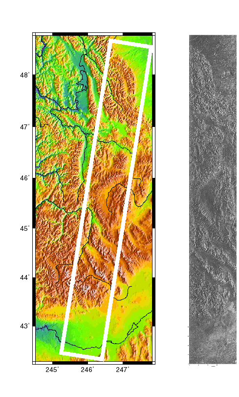
Figure 2. A 700 km long swath of ERS-2 SAR data collected at the SIO downlink site on January 13th, 1999. The data were focussed that evening on a SparcStation Ultra 5. The swath extends from Central Montana toward the southwest to the Snake River Plain, Idaho.
SIO, and in particular, the Institute for Geophysics and Planetary Physics (IGPP) have a long history of real-time data capture and archive including: two research vessels (Melville and Revelle) equipped with multibeam echo sounders, multichannel seismic data acquisition systems, magnetometers, gravimeters, and a host of seafloor instrumentation such as ocean bottom seismometers. Since much of this work is done thousands of kilometers from the nearest port, the systems must be robust to failures. In addition to these seagoing activities, IGPP operates many types of data acquisition systems and has the proper infrastructure for these activities. The systems include: partner in the Southern California Integrated GPS Network (SCIGN) consisting of more than 100 autonomous GPS receivers; the IDA network of 33 broadband seismometers at remote sites around the world; and the Cecil and Ida Green Piñon Flat Observatory where all types of geodetic equipment are deployed and tested. These systems at Piñon include: two continuously recording GPS receivers, VLBI measurements have been made at the site regularly, three long-baseline laser strainmeters, two radar reflectors aimed at ERS, two borehole strainmeters, several borehole tiltmeter systems, a modified LaCoste-Romberg gravity meter, an absolute falling-corner-cube gravity meter, a strong-motion seismic recorder (USGS); two (2) sets of Streckeisen seismometers (STS-1 VBB) and borehole tests of Geotech 54000 are also currently underway. This wide array of instrumentation at SIO is supported by numerous machine and electrical shops and extensive computer and network facilities. For a more complete description of research activities at IGPP see (
http://igpp.ucsd.edu/HTML/research_projects.html)8. REFERENCES — None
10. BUDGET
|
7/1/99-6/30/00 |
7/1/00-6/30/01 |
||
|
SALARIES: |
|||
|
David Sandwell, Professor of Geophysics |
n/c |
n/c |
|
|
Yehuda Bock, Research Geodesist |
n/c |
n/c |
|
|
Karen Watson, Graduate Student Researcher |
n/c |
n/c |
|
|
OTHER COSTS: |
|||
|
Maintenance of IGPP Mass Store (15%) |
6,000 |
6,000 |
|
|
TOTAL OTHER COSTS |
6,000 |
6,000 |
|
|
SUBCONTRACT: |
|||
|
Subcontract to Eurimage or SpotImage for Shared Use |
|||
|
of ERS-SAR Data (300 frames/year)* |
98,800 |
98,800 |
|
|
TOTAL DIRECT COSTS: |
104,800 |
104,800 |
|
|
INDIRECT COSTS: |
|||
|
51.5% on maintenance |
3,090 |
3,090 |
|
|
51.5% on first $25K of subcontract |
12,280 |
||
|
TOTAL INDIRECT COSTS: |
15,370 |
3,090 |
|
|
TOTAL COSTS: |
120,170 |
107,890 |
|
|
TOTAL AMOUNT REQUESTED |
228,060 |
||
|
*Note: 100 frames are proposed to be obtained through NSF funding. |
|||
DETAILED BUDGET EXPLANATION
The data costs are based on a quote from Eurimage for the right to downlink 400 frames per year. We plan to distribute these costs among three institutions, NASA, NSF and USGS. So far the three institutions have committed funds to purchase data from the ERS archive (NASA $50,000; NSF $26,000 and USGS about $40,000, Wayne Thatcher personal communication). We hope that NSF and USGS will continue to contribute to the data costs to help support this direct downlink effort. A proposal being considered by NSF, Major Research Initiative (MRI): Collaborative Research: Integrated Instrumentation for Broadband Observations of Plate Boundary Deformation — Barbara Romanowicz, PI, UC Berkeley is requesting 100 of the frames. Maintenance of the IGPP Mass Store ($6,000) is required for keeping the large data accessible to the users. The 400 frames per year could include new acquisitions, within our station mask, that have been proposed by other investigators under this SENH announcement.