HPCC/ESS GRAND CHALLENGE
APPLICATIONS AND ENABLING SCALABLE COMPUTING TESTBED(S) CAN RESEARCH PROPOSAL
Advanced Computing Technology Applications to
SAR Interferometry and Imaging Science
David W. Curkendall Principal Investigator (818) 354-2406
dwc@jpl.nasa.gov
Jet Propulsion Laboratory, California Institute of Technology
Contents:
ABSTRACT
We have assembled a balanced team of Synthetic Aperture
Radar (SAR) technologists, HPCC specialists, and Earth scientists to conduct
an aggressive program in scalable SAR computing technology with applications
to the Earth sciences. Our perspective is that by developing a core suite
of portable, scalable SAR software in image formation and image interferometry,
we can enable the instantiation of SAR processing capability on a large
percentage of NASA's, and indeed the entire nation's, inventory of HPCC
assets. Then by further developing a network computing model for this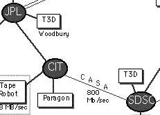 same software suite, we can access the raw data needed, bring that data
to any one or to multiple machines on that network for execution, and return
the results to a desired location. We focus on both scalable data processing
and scalable data movement. This positions SAR data processing advantageously
in two key respects:The processing can be moved away from special purpose
SAR correlators and positions its (high performance) execution within a
processing
on demand environment initiated and guided by the end user scientist.
same software suite, we can access the raw data needed, bring that data
to any one or to multiple machines on that network for execution, and return
the results to a desired location. We focus on both scalable data processing
and scalable data movement. This positions SAR data processing advantageously
in two key respects:The processing can be moved away from special purpose
SAR correlators and positions its (high performance) execution within a
processing
on demand environment initiated and guided by the end user scientist.
Many options are created for high volume SAR projects
including load balancing the computation over several institutionally managed
supercomputers. SAR is proving to be invaluable for a very wide variety
of Earth Science applications.[Evans, 95a] Accordingly, our Earth Science
sub team proposes to accomplish three distinct projects with these new
computation capabilities.
We propose in-depth scientific studies in:
-
Alpine glaciers world-wide,
-
Tectonic monitoring, and
-
Rain forest evolution assessment
SCIENCE TEAM
| INSTITUTION |
INVESTIGATOR |
RELEVANT DISCIPLINES |
| JPL |
Dr. Dave Curkendall, PI
Dr. C. Y. Chang
Dr. Bruce Chapman
Dr. Tony Freeman
Mr. Herb Siegel |
Computational Science
SAR Technology
Earth Science Ecology
Solid Earth Science
Computational Science |
| Caltech |
Dr. Paul Messina
Prof. Tom Prince |
Computational Science
SAR Technology |
| Scripps, UCSD |
Prof. B. Minster
Prof. D. Sandwell |
Solid Earth Science
Geodynamics |
| UCSB |
Prof. J. Dozier
Prof. J. Melack |
Earth Science
Hydrology Earth Science
Ecology |
Monitoring Strain Buildup
and Earthquake Displacements in California
The long-range objectives of our research are to understand
the kinematics and dynamics of active plate boundaries through precise
geodetic and geophysical measurements. Because the continental lithosphere
has a more complex layered rheology than the oceanic lithosphere, strain
across the major plate boundaries such as subduction zones and transform
faults is more diffuse on the continents than it is in the oceans. For
example, the strain along the 800 km long Eltanin transform fault in the
South Pacific is confined to a 30 km-wide zone along two major faults.
In contrast, the strain along the 800 km long San Andreas transform system occurs over a zone at least 200 km-wide containing
numerous parallel faults. Thus the continental tectonics are more complicated
and the location and timing of earthquake ruptures are less predictable.
Earthquake damage and loss of life is a major concern in Southern California
(e.g., January 13, 1994 Northridge earthquake). While timely earthquake
prediction may elude us for the foreseeable future, a better understanding
of the physics of the earthquake cycle may aid in earthquake preparation
and seismic hazard assessment. As has already been demonstrated by other
groups, the southwestern US is an ideal location to use interferometric
SAR methods to measure ground displacements (Figure 2 [Massonnet:93]; see
also [Zebker:94b]).
Andreas transform system occurs over a zone at least 200 km-wide containing
numerous parallel faults. Thus the continental tectonics are more complicated
and the location and timing of earthquake ruptures are less predictable.
Earthquake damage and loss of life is a major concern in Southern California
(e.g., January 13, 1994 Northridge earthquake). While timely earthquake
prediction may elude us for the foreseeable future, a better understanding
of the physics of the earthquake cycle may aid in earthquake preparation
and seismic hazard assessment. As has already been demonstrated by other
groups, the southwestern US is an ideal location to use interferometric
SAR methods to measure ground displacements (Figure 2 [Massonnet:93]; see
also [Zebker:94b]).
These applications have so far been confined to coseismic
and postseismic motions. We propose to use SAR interferometry to also measure
interseismic motions by interpolating between the existing array of permanent
GPS receivers (PGGA) coordinated by the Southern California Earthquake
Center with NASA and other funding. Over the next year we will install
radar reflectors at enough of these sites to provide 3-D control on SAR
images from RADARSAT and ERS-1/2. With a sufficiently accurate digital elevation model, repeating pairs of C-band SAR images can be used
to generate interference fringes. A major problem in interpreting these
images is caused by inaccuracies in the spacecraft position. A few radar
reflectors, imaged in the same 100 km by 100 km scene, could be used to
refine the positioning accuracy needed to detect small ground motions.
digital elevation model, repeating pairs of C-band SAR images can be used
to generate interference fringes. A major problem in interpreting these
images is caused by inaccuracies in the spacecraft position. A few radar
reflectors, imaged in the same 100 km by 100 km scene, could be used to
refine the positioning accuracy needed to detect small ground motions.
Being able to measure the complete deformation field in
space and time would be immensely valuable in understanding earthquake
hazard; because of our involvement in the Southern California Earthquake
Center we would be able to apply these results directly to this problem.
The region
that we propose to monitor is about 600 km by 300 km. One satellite, such
as RADARSAT, can provide complete coverage every 12 days. Single-look complex
(SLC) images at full resolution are needed to create interferograms. With
a pixel size of 4 by 8 m this corresponds to about 30 gigabytes of processed
SLC data every 12 days or about 1 terabyte a year. The raw SAR data are
somewhat larger and the processing of these data into SLC images is a formidable
task as described above. In addition, we hope to acquire data from other
satellites such as ERS-2, and JERS-1 which places additional demands on
the S4 system.
Extension of the CASA network with other computational
aspects include computing interferograms among possible coincident images,
unwrapping the phase maps of the deformation, and adjusting the interferograms
to match the GPS observations. Such a large scale of production will require
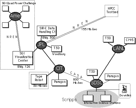
routine processing and archive at a supercomputer facility; the high speed
link to Scripps shown in Figure 1 will be used to interactively view and
validate the intermediate results. Our specific objectives are:
-
To generate a highly accurate, uniformly sampled digital
elevation model for the region. Such a product is fundamental to many areas
of research (e.g. hydrogeology) but in this case it also simplifies interferometric
SAR processing so that two images suffice to detect ground displacement.
-
To understand short-term transients associated with the delay
of the radar echo through the troposphere and ionosphere and mitigate the
contamination of the interferograms by these effects.
-
To use the repeat images to attempt to unravel the co-seismic,
post-seismic and interseismic components of crustal deformation within
the plate boundary zone. For this purpose, simultaneous analysis of data
collected by the dense GPS network and SAR images would permit us to take
advantage of the continuous temporal coverage of the former and the continuous
spatial coverage of the latter.
References
[Canizares 95] Letter from the National Research Council to NASA describing
their preliminary findings on the importance of SAR, Canizares, C.R., McElroy,
J.H.,April, 1995
[Chapman:94] "Validation and calibration of J-ERS-1 SAR imagery", B.
Chapman, M. Alves, and A. Freeman, J-ERS Results Reporting Meeting, December
1994, Tokyo, Japan
[Curkendall:94] Early Results in SAR and Visualization on the Cray T
Presentation at CUG, Oct. 94, Tours, France.
[Evans:95] Spaceborne Synthetic Aperture Radar: Current Status and Future
Directions, Space Studies Board, National Research Council, NASA, Evans,
D.L., Editor, April, 1995
[Feigl:93] Space Geodetic measurements of crustal deformation in Central
and Southern California, Feigl, K., D. C. Agnew, Y. Bock, D. Dong, A. Donnellan,
B. Hager, T. Herring, D. D. Jackson, T. H. Jordan, R. W. King, S. Larsen,
K. M. Larson, M. H. Murray, Z. Shen, and F. Webb, 1984-1992, J. Geophys.
Res., 98, 21677-21712, 1993.
[Freeman:94]"Amazon rain forest classification using JERS-1 SAR data",
A. Freeman, C. Kramer, M. Alves, and B. Chapman, JERS Results Reporting
Meeting, December 1994, Tokyo, Japan
[Gabriel:89] Mapping small elevation changes over large areas: differential
radar interferometry; Gabriel, A.K., Goldstein, R.M., and Zebker, H.A.;
Journal of Geophysical Research, Vol. 94, no. B7, pp. 9183-9191
[Hess:95] "Delineation of inundated area and vegetation along the Amazon
floodplain with the SIR-C synthetic aperture radar",Hess, l.L., J.M. Melack,
S. Filoso and Y. Wang, IEEE Trans. Geosc. Remote Sens., 1995.
[JERS-1:94] JERS-1 Data Users Handbook, Earth Observation Center, National
Space Development Agency of Japan, Dec. 1994 [Massonnet:95] The displacement
field of the Landers earthquake mapped by radar interferometry, Massonnet,
D., M. Rossi, C. Carmona, F. Adragna, G. Pelzer, K. Feigl, and T. Rabaute,
Nature, 364, 138-142, 1993.
[Mertes:95] "Spatial patterns of hydrology, geomorphology and vegetation
on the floodplain of the Amazon river in Brazil", Mertes, A.K.L., D.L.
Daniel, J.M. Melack, B. Nelson, L.A. Martinelli and B. Forsberg, J. Geomorphology,
1995.
[RADAMBRASIL:83] Projecto RADAMBRASIL, Ministerio das Minas e Energia,
Departamento Nacional de Producao Mineral, Levantamento de Redurso Natukrais,
Vols. 1-23, Rio de Janeiro, 1973-1983.
[Rott:92] Multifrequency and polarimetric SAR observations on alpine
glaciers, H. Rott and R. E. Davis, Annals of Glaciology, 17: 304-308, 1992.
[Shi:94] Snow mapping in alpine regions with synthetic aperture radar,
J. Shi, J. Dozier, and H. Rott, IEEE Transactions on Geoscience and Remote
Sensing, 32(1): 152?158, 1994.
[Siegel:94] "Parallel Processing of Spaceborne Imaging Radar Data,"
Payne, D., Phung, T., Miller, C., Siegel, H., Williams, R., Consurrent
Supercomputing Consortium Annual Report 1993-1994
[Stein:89] Hidden earthquakes, Stein, R. S., and R. S. Yeats, Sci. Am.,
260, 48-57, 1989.
[Wang:95] "Detection of flooding in Amazonian forests : results from
canopy backscatter modeling", Wang, Y., S. Filoso, L. Hess, and J.M.Melack,
Remote Sensing of the Environment, 1995
[Zebker:86a] Topographic Mapping from Interferometric SAR Observations;
Zebker, H. and Goldstein, 1986l Journal of Geophysical Research, Vol. 91,
B5, pp. 4993-4999
[Zebker:94b] On the derivation of coseismic displacement fields using
differential radar interferometry: The Landers earthquake, Zebker, H. A.,
P. A. Rosen, and R. M. Goldstein, J. Geophys. Res., 99, 19617-19634, 1994
 same software suite, we can access the raw data needed, bring that data
to any one or to multiple machines on that network for execution, and return
the results to a desired location. We focus on both scalable data processing
and scalable data movement. This positions SAR data processing advantageously
in two key respects:The processing can be moved away from special purpose
SAR correlators and positions its (high performance) execution within a
processing
on demand environment initiated and guided by the end user scientist.
same software suite, we can access the raw data needed, bring that data
to any one or to multiple machines on that network for execution, and return
the results to a desired location. We focus on both scalable data processing
and scalable data movement. This positions SAR data processing advantageously
in two key respects:The processing can be moved away from special purpose
SAR correlators and positions its (high performance) execution within a
processing
on demand environment initiated and guided by the end user scientist.