What exactly is an earthquake? An earthquake is a natural event inside the Earth which releases built-up energy. Earthquakes release energy and create seismic waves, which cause the shaking we feel. It's important to be clear: an earthquake is not the shaking we feel. An earthquake is the event which makes the seismic waves (we'll talk about them in a bit) which cause the shaking we feel.
In 1906, there was a large earthquake along the San Andreas Fault in northern California. In the course of field investigations, which among other surprises showed that some spots along the San Andreas had moved by as much as 7 meters, H.F. Reid developed the theory which is most used today to explain earthquakes: the elastic rebound theory.
The elastic rebound theory basically works like this. The rocks along a fault are held together by friction and cannot slip relative to each other. Over time, background geologic forces (which we now know to be mostly plate motions) apply a stress to the rocks on either side of the fault. The blocks of rock ``want'' to slide past one another, but cannot because of the friction holding them together. Instead, they deform around the fault, building up strain energy. Eventually, there comes a point when the strain energy is greater than the strength of the friction holding the rocks together, and they slide past one another abruptly. Voilà -- an earthquake.
Grant Lindley at UCSB has a really cool elastic rebound animation (if you have Java) and some nice pics (if you don't).
Now, there are other kinds of earthquakes which are not directly caused by faults sliding due to plate tectonic stresses. Earthquakes are sometimes caused by volcanoes, by filling reservoirs, by pumping fluids in or out of the ground, and by stresses imposed by big underground nuclear explosions. These sorts of earthquakes are certainly the minority, however.
When an earthquake occurs, it makes seismic waves, which cause the shaking we feel. Seismic waves are essentially just the jiggling of the ground in response to the force put on the ground by the earthquake, similar to the way the jello in a bowl responds to a tap to the side of the bowl. There are three major kinds of seismic waves: P, S, and surface waves. P and S waves together are sometimes called body waves because they can travel through the body of the earth, and are not trapped near the surface.
A P wave is a sound wave traveling through rock. In a P wave, the rock particles are alternately squished together and pulled apart (called compressions and dilatations), so P waves are also called compressional waves. These waves can travel through solids, liquids, and gases. P waves can travel through the liquid outer core.
An S wave is a different beast. In an S wave, the rock particles slide past one another, undergoing shear -- so an S wave is also called a shear wave. You can make shear waves by, for example, tying a rope to a tree and shaking the free end of the rope up and down or side-to-side. The waves themselves will travel forward, toward the tree. But the rope particles will stay in one place, sliding back and forth past each other. Shear waves cannot travel in liquids or gases -- so, for example, S waves don't travel through the ocean or through the outer core.
Surface waves are called surface waves because they are trapped near the Earth's surface, rather than traveling through the ``body'' of the earth like P and S waves. There are two major kinds of surface waves: Love waves, which are shear waves trapped near the surface, and Rayleigh waves, which have rock particle motions that are very similar to the motions of water particles in ocean waves.
Seismology is the science of studying earthquakes. Seismologists are scientists who practice seismology (some of them get good at it, too ;-) ). We record ground shaking with an instrument called a seismometer, and the instrument makes a recording on a device called a seismograph -- sometimes on paper with ink, but mostly these days with digital computers. The recording itself is called a seismogram.
Most classical seismometers have either a heavy mass on a suspension system, like a spring, or a mass at the end of an arm which swings like a fence gate. Seismometers work by sensing the relative motion of the heavy mass and the frame of the seismometer itself. The mass ``wants'' to stay in one place due to inertia, while the frame of the instrument has to move with the ground, since the frame is firmly attached to the ground. This relative motion is sensed by the instrument, and is what is recorded by the seismograph to make a seismogram.
Charlie Thompson has built a homebrew seismometer which has the ``fence gate'' design.
Most modern instruments are actually completely computerized, and work by sensing how hard they have to work to make the mass move with the rest of the instrument. This record of the force necessary to make the mass move is stored digitally in a computer connected to the seismometer, and sent via phone lines or the Internet to a processing center, where seismologists use computers to look at the records and play with the earthquakes. These days, most seismic data processing never actually involves paper records -- though I have one of my favorite paper records in a frame on my wall.
The folks at the UC Berkeley Seismographic Station have a really cool site where you can make your own seismogram.
One question lots of people ask me is: ``How do you locate an earthquake?'' It turns out that, while the procedure is not entirely straightforward, it is not all that difficult to locate an earthquake. I'll tell you how we locate local earthquakes; distant earthquakes are located using similar methods, but they are a bit more complicated than we need to worry about.
You will recall from the discussion in Section 3 that there are three major kinds of seismic waves: P, S, and surface waves. P waves travel faster through the Earth than do S waves, so P waves arrive before S waves do. If you have a seismogram, and you know how to measure time accurately on it, you can pick the arrival times of the P wave and the S wave. Next, you figure out how far apart these waves arrive, called the S-P time. You can then go to a table of distance as a function of S-P time and work out how far away the earthquake was from your station. If you have three or more stations, you can draw circles on a map, and where the circles meet is the location of your earthquake. Essentially, you are triangulating the earthquake's location.
Go look over here to see an example (with images) on earthquake location.
Most people living in California have heard about the ``Richter Scale'' and have at least a vague idea that it is used to measure the sizes of earthquakes. Most people that I know, though, have some misconceptions about the Richter Scale -- for example, someone once asked me if he could see where I kept my Richter Scale! Also, there are some important differences between magnitude, energy, and intensity that need to be discussed.
C.F. Richter at Caltech invented the idea of earthquake magnitudes in 1935 as a way to compare earthquakes. He was into astronomy and knew that astronomers used magnitude scales to compare the brightnesses of stars, so he adapted the idea for seismology. Richter based his scale on the way ground motion was recorded by a specific type of seismometer that was very common back in the 1930's, called a Wood-Anderson seismometer. It is very important for you to realize here that the Richter Scale is completely arbitrary; it was made up by Richter.
Basically, if you know how far away an earthquake is from your station, and you have a record from the earthquake, you can calculate its Richter magnitude. You do that by measuring the maximum amplitude of the shaking recorded by the W-A instrument, taking the logarithm of that amplitude, and adding in a number to take into account distance from the station. The key thing here is that the magnitude scale is logarithmic; for every one full point change in magnitude, the amount of shaking recorded by a seismometer will go up by a factor of 10.
Richter magnitude is useful, but limited; it is only defined for local earthquakes. Other magnitude scales have been developed to handle earthquakes that are distant from the seismometer making a given magnitude estimate, and these have been made to give magnitudes which are basically similar to Richter magnitudes. However, all of these scales have the same two fatal flaws. First, all of them become inaccurate at large magnitudes, and in fact, above about magnitude 8 or so, the magnitudes just don't get bigger (even though the earthquakes do). Second, these magnitude scales are all empirical; they don't actually tell you anything about the physics of the earthquake itself.
Recently, a new magnitude scale has been developed which has neither of these flaws: the moment magnitude scale. Unlike all the other kinds of magnitude, moment magnitude tells you something about the physical size of the earthquake. Moment magnitude really is physically meaningful. Also, moment magnitude is never overwhelmed by large earthquakes, and so it is possible to get meaningful estimates of magnitude even for humungous quakes. As an example of this, recently people have gone back and recomputed magnitudes for earthquakes such as the 1964 Alaska earthquake. Previously, the magnitude had been given as 8.6 - pretty damn big, but nothing compared to the 9.2 which is now accepted (remember that magnitude scales are logarithmic). Moment magnitudes are now the accepted magnitude among seismologists, and are usually the numbers given to the press.
Another way of looking at the size of earthquakes is to figure out how much energy they release. Some rules of thumb have been found to compare magnitude to energy, and it has been found that for each one point magnitude increase (say from a 4 to a 5), 32 times as much energy is released. If one jumps from a 5 to a 8, the energy goes up by 32 x 32 x 32, which is almost a factor of 33,000 -- but don't worry. While the total energy goes up that much, it does so not because the ground shakes 33,000 times harder, but instead because large earthquakes release energy for much longer and over a much wider area than do smaller earthquakes.
Finally, there is another way of looking at the strength of earthquakes, which depends not on records of earthquakes but on how the earthquake was perceived by people and how much damage is done. This is called intensity, and is described using the Mercalli Scale. While there will be very little variation in magnitude estimates for a given earthquake, intensity measurements can (and do) vary widely. Intensities vary based on the distance from the earthquake, what the person making an intensity report was doing at the time of the earthquake (intensity would be lower from someone who was air-guitaring to Van Halen than from someone sitting quietly playing a viola, for example), by what kind of building they were in, what kind of soil they were on, etc. Intensities are inherently subjective, but can be of use to engineers who try to build earthquake-resistant buildings, for example.
More than 95% of the world's earthquakes occur in discrete belts throughout the world. The existence of these belts is one piece of evidence in support of plate tectonics. In fact, we now know these belts are plate boundaries. Earthquakes occur along all types of plate boundaries: subduction zones, transform faults, and spreading centers.
However, there are earthquakes which occur within plates. For example, the New Madrid area of Missouri (1811-1812), Charleston, South Carolina (1889), Boston (1755), and Hawaii (1975) are all places which have large earthquakes. In fact, in 1811-12 there were four very large earthquakes in the New Madrid area, which are believed to have been in the low magnitude 8 range (there are no actual recordings from which to figure out magnitudes...). These earthquakes actually rang church bells in Boston -- over 1700 kilometers away! -- and caused damage as far away as Washington D.C, more than 1100 kilometers away. There are also stories that say these earthquakes made the Mississippi River flow backwards for a short time!
Earthquakes which occur within plates (intraplate earthquakes) are among the remaining mysteries for plate tectonics, because plate tectonics cannot strictly explain their occurrence. In some places, such as Hawaii, the earthquakes are related to volcanism, but for the most part, intraplate earthquakes are as yet not fully understood.
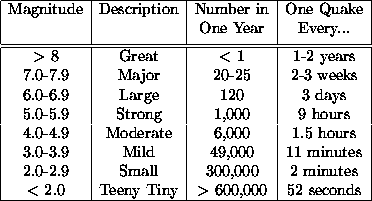
Earthquakes happen constantly around the world. In an average year, there might be 20-25 magnitude 7 earthquakes globally -- about one every 2 to 3 weeks. On the other end of the magnitude scale (re-read Section 6 if you like), there are literally hundreds of thousands of tiny earthquakes worldwide in a given year.
Here's a little table with worldwide average rates:
``I heard that earthquake was so big it broke the Richter Scale!'' Believe it or not, I once had someone call me and tell me that. Of course, if you guys had been around, you'd have been able to tell the caller that the Richter Scale is not a physical thing, and thus can't be broken.
However, the caller's comment brings up an interesting question: how big can an earthquake get? Unfortunately, I can't give you a simple answer here. The maximum magnitude earthquake that a given fault can generate is determined by a number of factors. A long fault can generate a larger earthquake than a short fault, all other things being equal. A fault which tends to break and have the rocks jump farther than another fault will tend to generate larger earthquakes than that other fault. And the strength of the rocks is another factor: stronger rocks will tend to hold out longer, and generally break in a larger earthquake, than will weaker rocks.
I'm not sure how big the theoretical maximum size earthquake is period, but I can tell you that the largest earthquake ever recorded was in Chile, on 22 May 1960. It had a moment magnitude of 9.6, broke an area of fault 850 kilometers long and more than 120 kilometers wide, and generated a lot of damage and a humungous (taller than 30 feet in some places along the Chilean coast) tsunami. This earthquake released about as much energy as would be released by blowing up one billion tons of TNT!
At the other end of things, there is no limit to how small earthquakes can get. The instrumental limit is that, in the quietest locations with the most sensitive seismometers and earthquakes extremely near to the seismometer, it is possible to record earthquakes as small as magnitude -2. An earthquake that small would rupture a circular fault roughly 7 centimeters across and move it about 1 centimeter -- a tiny, tiny, tiny earthquake.
People generally stop feeling earthquakes when they drop below about magnitude 3 or so, although I know of a case where a magnitude 2.3 earthquake was felt by someone sitting very quietly in a house which was right on top of the epicenter.
Just as an aside, there was a great earthquake (magnitude 8.2) in Bolivia in 1994 at a depth of about 630 kilometers which was actually felt in North America. The earthquake was felt in high-rise buildings as far away as Renton, Washington -- which is almost 8700 kilometers from the epicenter! This is the greatest distance over which any earthquake is known to have been felt anywhere in the world.
The primary effects of earthquakes are ground shaking, ground rupture, landslides, tsunamis, and liquefaction. Fires are probably the single most important secondary effect of earthquakes.
Ground rupture is another important effect of earthquakes which occurs when the earthquake movement along a fault actually breaks the Earth's surface. While active ground rupture is comparatively rare, there have been cases of it in California -- for example, during the 1906 earthquake, fences near Pt. Reyes were offset by as much as 7 meters. And in the Owens Valley earthquake in 1872, a fault scarp as much as 8 meters high broke the ground near Lone Pine. Rupture causes problems for humans by, well, rupturing things; pipelines, tunnels, aqueducts, railway lines, roads, and airport runways which cross an area of active rupture can easily be destroyed or severely damaged.
Landslides are caused by earthquakes both by direct rupture and by sustained shaking of unstable slopes. They can easily destroy buildings in their path, or block roads and railroad lines, or take hilltop homes with them as they tumble. They even can dam rivers on occasion, like in the 17 August 1959 Hebgen Lake earthquake (magnitude 7.1) in Montana.
Tsunamis, which are popularly -- and incorrectly -- known as ``tidal waves,'' are a grave hazard to many parts of the world, particularly around the Pacific Ocean basin. Tsunamis are a series of water waves caused when the seafloor moves vertically in an earthquake (which is why they are uncommon in California earthquakes -- most CA earthquakes are strike-slip, with little or no vertical motion) and which can travel vast distances in a short period of time. Tsunami speeds in the deep ocean have been measured at more than 700 km/hr, comparable to some jet planes, and when tsunamis reach shallow water near the coast, they can reach heights of more than 27 meters (90 feet)! Remember that tsunamis are a series of waves, and may start with a gentle withdrawal of water, followed by a very abrupt arriving wave, followed by another withdrawal, etc. The safest thing to do if you hear a tsunami is coming is to move to higher ground away from the beach as quickly as possible.
Liquefaction and subsidence of the ground are important effects which often are the cause of much destruction in earthquakes, particularly in unconsolidated ground. Liquefaction is when sediment grains are literally made to float in groundwater, which causes the soil to lose all its solidity. Subsidence can then follow as the soil recompacts. Sand blows, or sand volcanoes, form when pressurized jets of groundwater break through the surface. They can spray mud and sand over an area a few meters across. All of these effects pose a grave danger to buildings, roads, train lines, airport runways, gas lines, etc. Buildings have actually tipped over and sunk partway into liquefied soils, as in the 1964 Niigata earthquake in Japan. Underground gas tanks and septic tanks (yuck!) have been known to float to the surface through liquefied soils. All told, liquefaction and associated effects resulted in more than $20 billion damage in the 1995 Kobe earthquake, and similar levels of damage are possible in US port facilities during a large earthquake.
Fires are a major source of damage after earthquakes. Ground rupture and liquefaction can easily rupture natural gas mains and water mains, both contributing to the ignition of fires and hindering the efforts to control them. In an amazing example of this, during the 1994 Northridge earthquake there were actually places where water was pouring down streets from broken water mains -- and at the same spot and same time, fire was roaring out of ruptured gas mains! Shaking also contributes to starting fires, by knocking down power lines, spilling flammable liquids from storage containers, and tossing hot coals from barbeques and stoves. In the 1923 Kanto earthquake in Japan nearly 100,000 people died -- over 70,000 of them due to fires which swept the area after the earthquake. And of course most of the damage in San Francisco from the 1906 earthquake was caused by the subsequent fires.
Now, with all these types of major damage, people often ascribe malevolence to earthquakes. Please keep in mind: not a single person has ever been killed directly by an earthquake. It is the fact that we humans persist in building things which are prone to failure in earthquakes, and then living in and around these buildings, that results in deaths during earthquakes. Earthquakes are mindless natural phenomena; we aren't.
Sorry to disappoint those on the East Coast who would love to have us disappear, but there is no chance that California will fall off and sink into the ocean. Since the the major faults in California are mostly strike-slip, and have little or no vertical motion, there is no way for large blocks of California to fall off. Note that I am not saying that some parts of the state don't fall into the ocean every day in landslides. What I am talking about is the ridiculous belief that huge chunks of California are going to tear away and go sinking into the brine.
Of course, this is not to say that California won't undergo some changes as a result of plate tectonics. If nothing else, the sliver of California which is southwest of the San Andreas Fault is on a different plate from the rest of California. This sliver contains Los Angeles and San Diego, and is moving northwest relative to the rest of the state at a rate of a few centimeters each year - so that in about 20 million years, Los Angeles will be a suburb of San Francisco.
There has never been any recorded case of an earthquake causing cracks to open up and swallow cities. Certainly, earthquakes can cause cracks to form in the Earth, such as happened during the Loma Prieta earthquake in 1989. However, these cracks are generally quite small and only rarely do they exceed a meter or two in width. And certainly these cracks don't again close up and swallow somebody whole.
In fact, there is only one case that I am aware of in which anyone actually died as a direct result of becoming trapped in an earthquake-caused crack. In the 1906 earthquake, near the town of Olema on Pt. Reyes, there was such a casualty -- to a cow, which fell into a crack and was killed.
On hot days with no wind, some people will tell you that an earthquake is coming -- that it is ``earthquake weather'', and you'd better be ready. That is simply not true.
The myth of ``earthquake weather'' dates back to the 4th century B.C. Greek philosopher Aristotle. Aristotle believed that earthquakes were caused by winds rumbling around in huge underground caverns, restlessly searching for a way out to the surface. These winds were trapped below ground, so there would be no wind above ground, and it would be stiflingly hot. Clearly, Aristotle was wrong.
However, his folly took hold and even today, there are people who believe in ``earthquake weather.'' To date, however, there have been numerous studies done to try to find a link between weather and earthquakes. No such link has been found.
One of my friends, Dr. Robert Uhrhammer at the UC Berkeley Seismographic Station, has this to say about ``earthquake weather'': `` `Earthquake weather' is whatever the weather was during the last big earthquake.'' In other words, people sometimes see patterns when there are no patterns to be seen. ``Earthquake weather'' simply does not exist.
ES 10
Lecture 20 - Earthquakes
Greg Anderson
This document was generated using the LaTeX2HTML translator Version 96.1 (Feb 5, 1996) Copyright © 1993, 1994, 1995, 1996, Nikos Drakos, Computer Based Learning Unit, University of Leeds.
The command line arguments were:
latex2html lecture20.tex.
The translation was initiated by Greg Anderson on Fri Feb 28 16:14:29 PST 1997
Greg Anderson