Somewhat surprisingly, these were the questions that gave people the most trouble. Mostly, people had problems with problems 2 and 3.
A general comment first: there is no 'h' in plate tectonics. For some reason, lots of people wanted to spell it "techtonics". For the record, it's spelled "tectonics".
There are lots of different kinds of evidence for plate tectonics. They are discussed in the notes for Lecture 6, in the book, and on the really nice USGS web document This Dynamic Earth, which you get to through the lecture notes for Lecture 4. I will list several here, in no particular order.
- Earthquakes
- You can use earthquakes to infer the locations of plate boundaries and subducting lithosphere as well as the sense of motion along transform faults. Plate tectonics predicts the same sense of motion along transfor faults as is observed using earthquakes.
- Seafloor Bathymetry
- New crust formed at mid-ocean ridges is hot and buoyant and it sinks as it cools. The actual depth of the ocean as a function of age can be predicted very well from thermal models of a cooling slab in contact with cold sea water.
- Lack of thick sediments along the seafloor
- The lack of thick sediments along the seafloor indicates that the seafloor must be quite young, otherwise erosion would have deposited thick layers of sediment on the seafloor. Since the seafloor is so young, and the earth is so old, something must be happening to make new seafloor.
- Seafloor magnetic anomalies
- If you know from other data when Earth's magnetic field has reversed its polarity, you can use seafloor magnetic anomalies (the stripes) to estimate the age of the seafloor. Once you have made such estimates, you could go out and drill into the seafloor and bring up rocks whose ages you could then determine. If one in fact does this, the ages you determine match well.
More importantly, you can determine that the age of the seafloor depends on how far you are from mid-ocean ridges - the farther, the older, and the ages are basically symmetric across the ridge. Thus, new seafloor must be made at ridges and spread apart from there.
- Apparent Polar Wander Paths (APWP)
- If one goes out and measures the magnetic properties of rocks of varying ages, one can determine APWP from the different layers (and thus ages) of rock. If one determines APWP in both Africa and South America for rocks formed more than 225 Ma, they don't match up, but if you move Africa and South America together, they do match up. This indicates that the rocks were formed at the same time in the same spot and have drifted apart.
- Matching coastlines
- It seems clear that the continental margins of Africa and South America look as though they would fit together. One can do such reconstructions and find that, in fact, they do fit.
- Fossil evidence
- Fossils of very similar plants and animals are found on continents which are today widely separated. How did they swim across the oceans? If one assumes that the continents were actually together at the time the animals were buried, one can better explain this phenomenon.
- Similar rock sequences
- Very similar and similarly aged sequences of rock layers are found in widely separated parts of the world (Africa, South America, Australia, India and Antarctica). Again, assuming the continents were connected at the time of the formation of these layers, one can better explain this evidence.
- Continuity of old mountain belts and old glacial evidence
- Mountain belts which were formed more than 225 Ma and are widely separated today form continuous belts if you reassemble the continents. Also, glacial deposits and scour marks formed in a similar time are found all around the world in a pattern which is very hard to explain without reassembling the continents; the observed pattern is easy to explain if one does reassemble them.
Please note that Pangaea is not evidence for plate tectonics. Pangaea is a theoretical construct, since no one was around to see if the continents really were assembled to form Pangaea. The evidence which led Wegener to propose Pangaea, however, is evidence for plate tectonics.
It did not matter to me which five you chose, as long as you listed at least five different ones, and gave a brief explanation which convinced me you knew what was important about each one (like the explanations I've given above).
This question is akin to asking "What is the source of energy for the force which makes a car move?" The answer to that question is, of course, the gas which is burning in the engine of the car. So in effect, you were asked to tell me what the plate tectonic "gas" is.
The answer is heat from Earth's interior is the gas for plate tectonics. This heat comes from radioactive decay (mostly of uranium and thorium) as well as the heat left over from the formation of Earth. Heat is what makes convection in the mantle, but convection cannot happen without the heat, and so convection itself is not the source of energy for plate tectonics.
If you told me "heat from radioactive decay and residual heat of formation", you got all the points.
You can read more about this answer on the USGS page This Dynamic Earth.
This question, in keeping with the car analogy above, is asking "What is the force which makes a car move?" The answer to that question is not the gas burning in the engine, but rather the force of friction between the ground and the rotating tires of the car. In this question, you were effectively being asked what the "tires" for plate tectonics are.
The answer is that currently, most earth scientists feel that the weight of cold lithosphere sinking into the mantle at subduction zones, which the pulls the rest of the plate behind it, is the driving force. This is called "slab pull". Other driving forces which are mentioned in your book and on the USGS page This Dynamic Earth are:
In order to get all the points you had to list "slab pull" as the currently-accepted driving force as well as giving two of the three other forces.
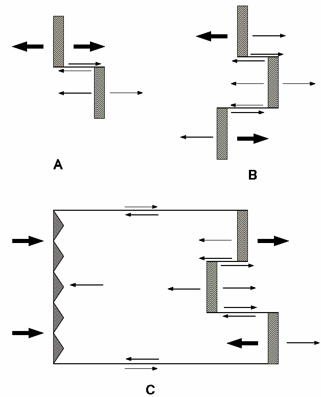
In this problem, you had to supply the missing arrows (the thin arrows in the figures below) which completed the description of the plate motions for the scenarios you were given. Most people did well, and those that had problems seemed to generally have problems (a) remembering to draw arrows for the transform faults and (b) making sure their arrows pointed the correct directions. I have drawn the necessary arrows as thin arrows in the figures below.
Each arrow was worth 1 point, and there were a total of 25 necessary arrows.
I was quite pleasantly surprised to see that very few people had major problems with this problem, and that in fact, most people did very well on it.
Here are the places which gave people the most trouble:
Overall, though, most folks did well.
So, the answers:
The upshot is that my spreading rate estimate for the Pacific-Antarctic Rise is 46.27 mm/year and for the Reykjanes Ridge, I estimate a spreading rate of 15.11 mm/year.
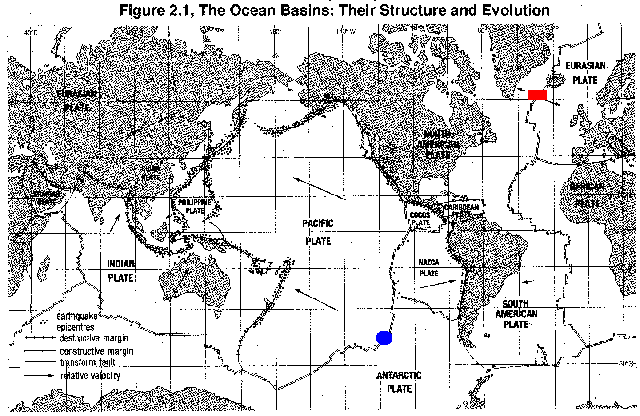
The red box is the location of the Reykjanes Ridge and the blue oval is the location of the Pacific-Antarctic Rise.
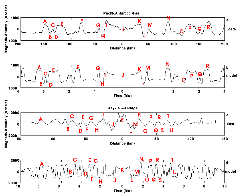
My picks for the peaks and valleys, labeled with letters.
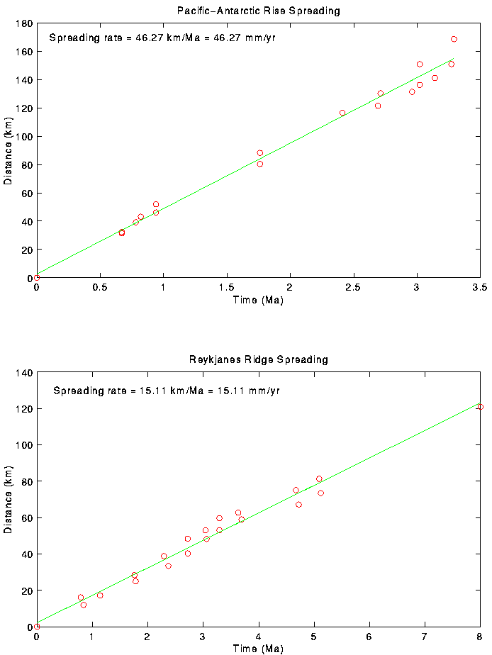
My plate spreading rate plots
Greg Anderson