``I'm afraid I can't comment on the name Rain God at this present time, and we are calling him an example of a Spontaneous Para-Causal Meteorological Phenomenon.''Seems an appropriate quote for a lecture full of jargon...``Can you tell us what that means?''
``I'm not altogether sure. Let's be straight here. If we find something we can't understand we like to call it something you can't understand, or indeed pronounce...
``...And if it turns out that you're right, you'll still be wrong, because we will simply call him a ... er, `Supernormal' -- not paranormal or supernatural because you think you know what those mean now, no, a `Supernormal Incremental Precipitation Inducer.' We'll probably want to shove a `Quasi' in there somewhere to protect ourselves. Rain God! Huh, never heard such nonsense in my life. Admittedly, you wouldn't catch me going on holiday with him. Thanks, that'll be all for now, other than to say `Hi!' to Wonko if he's watching.''
-- Douglas Adams, So Long, And Thanks For All The Fish
Before you can learn anything about global, regional, or local seismology, there are a few basic ideas you need to have seen. We begin with some basic terms:
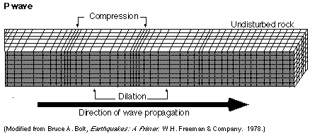
A P wave is a sound wave traveling through rock. In a P wave, the rock particles are alternately squished together and pulled apart (called compressions and dilatations), so P waves are also called compressional waves. These waves can travel through solids, liquids, and gases. P waves can travel through the liquid outer core.
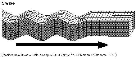
An S wave is a different beast. In an S wave, the rock particles slide past one another, undergoing shear -- so an S wave is also called a shear wave. You can make shear waves by, for example, tying a rope to a tree and shaking the free end of the rope up and down or side-to-side. The waves themselves will travel forward, toward the tree. But the rope particles will stay in one place, sliding back and forth past each other. Shear waves cannot travel in liquids or gases -- so, for example, S waves don't travel through the ocean or through the outer core.
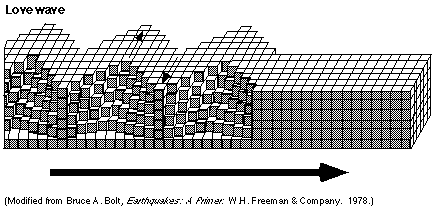
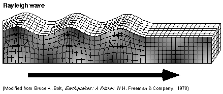
Surface waves are called surface waves because they are trapped near the Earth's surface, rather than traveling through the ``body'' of the earth like P and S waves. There are two major kinds of surface waves: Love waves, which are shear waves trapped near the surface, and Rayleigh waves, which have rock particle motions that are very similar to the motions of water particles in ocean waves.
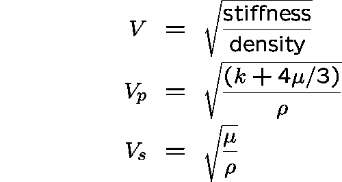
Keep in mind that P- and S-waves travel at different speeds, but that both P- and S-wave speeds depend on density and ``stiffness'' of the rock they travel through. Here are the equations which govern wave speed:
What you need to know about this is that
The wave images on this page come from the UPSeis program at Michigan Technological University.
Seismology is the science of studying earthquakes. Seismologists are scientists who study earthquakes. We record ground shaking with an instrument called a seismometer, and the instrument makes a recording on a device called a seismograph -- sometimes on paper with ink, but mostly these days with digital computers. The recording itself is called a seismogram. This is, of course, all review from earlier, but it helps introduce the next bit...
Most classical seismometers have either a heavy mass on a suspension system, like a spring, or a mass at the end of an arm which swings like a fence gate. Seismometers work by sensing the relative motion of the heavy mass and the frame of the seismometer itself. The mass ``wants'' to stay in one place due to inertia, while the frame of the instrument has to move with the ground, since the frame is firmly attached to the ground. This relative motion is sensed by the instrument, and is what is recorded by the seismograph to make a seismogram.
Charlie Thompson has built a homebrew seismometer which has the ``fence gate'' design.

Most modern instruments are actually completely computerized, and work by sensing how hard they have to work to make the mass move with the rest of the instrument. This record of the force necessary to make the mass move is stored digitally in a computer connected to the seismometer, and sent via phone lines or the Internet to a processing center, where seismologists use computers to look at the records and play with the earthquakes. These days, most seismic data processing never actually involves paper records -- though I have one of my favorite paper records in a frame on my wall.
The folks at the UC Berkeley Seismographic Laboratory have a really cool site where you can make your own seismogram.
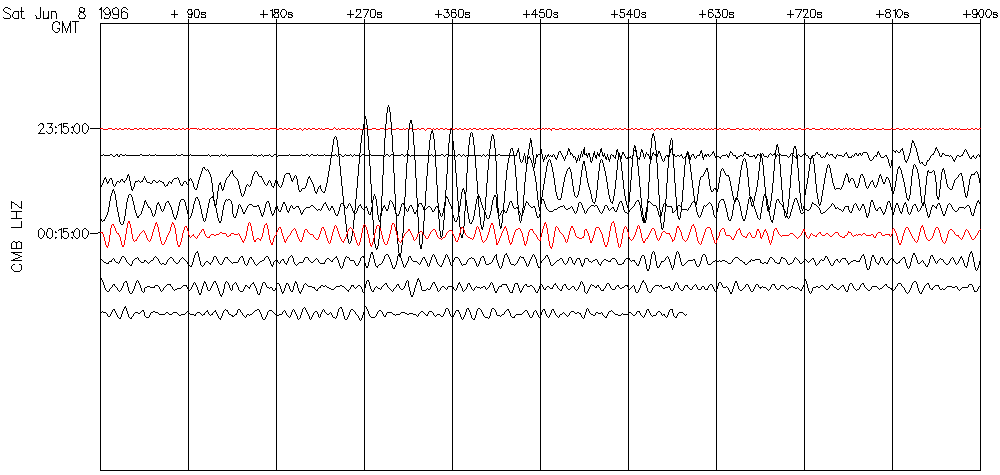
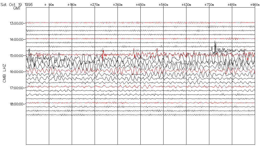
Below are a few example seismograms which I made using the UC Berkeley tool. Most are seismograms from the CMB station, which is in the Sierra foothills at Columbia College. The Northridge record is from the BKS site which is located just east of the UC Berkeley campus.
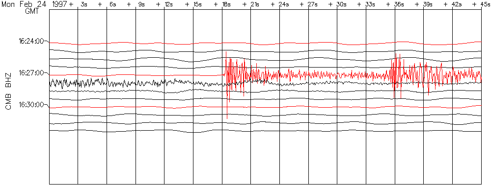
This is a recording of a magnitude 3.6 earthquake 13 km SE of Mammoth Lakes which happened at 1626 UT (8:26 am PST) on 24 February 1997. Note the clear P and S wave arrivals at about 16:26:18 and 16:26:35 respectively.
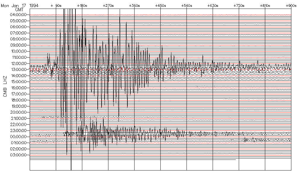
This is a recording of the 17 January 1994 Northridge earthquake (M6.7) near Los Angeles at 1230 UT (5:30 AM PST). This earthquake is about 525 km away from BKS. Note there is an M 5.9 aftershock which is lost in the arrivals from the main event. Other aftershocks are visible at 1507 (M 4.2), 2046 (M 4.9), and 2333 UT (M 5.6).
This is a recording of a magnitude 6.5 earthquake in the Andreanof Islands on 08 June 1996 at 2319 UT (4:19 pm PDT). This earthquake is about 4700 km away from CMB and is a shallow earthquake. The waves with the highest amplitude (the ``biggest wiggles'') are the surface waves, which is typical in large, shallow, distant earthquakes.
This is a recording of a magnitude 6.9 earthquake in the Tonga Islands on 19 October 1996 at 1453 UT (6:53 am PST). This earthquake is about 8900 km from CMB and is a deep earthquake, with a depth of about 590 kilometers. Note that the surface waves here are fairly weak; typically, deep earthquakes don't generate strong surface waves.
One question lots of people ask me is: ``How do you locate an earthquake?'' It turns out that, while the procedure is not entirely straightforward, it is not all that difficult to locate an earthquake. I'll tell you how we locate local earthquakes; distant earthquakes are located using similar methods, but they are a bit more complicated than we need to worry about.
You will recall from the discussion earlier that there are three major kinds of seismic waves: P, S, and surface waves. P waves travel faster through the Earth than do S waves, so P waves arrive before S waves do. If you have a seismogram, and you know how to measure time accurately on it, you can pick the arrival times of the P wave and the S wave. Next, you figure out how far apart these waves arrive, called the S-P time. You can then go to a table of distance as a function of S-P time and work out how far away the earthquake was from your station. If you have three or more stations, you can draw circles on a map, and where the circles meet is the location of your earthquake. Essentially, you are triangulating the earthquake's location.
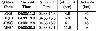
An example is probably useful. Below, you will see a seismogram from a seismometer in northern California called BKS. You should see an earthquake recording (the squiggly line), and specifically note that there are two points in the record at which the size of the signal (what seismologists call the amplitude) jumps fairly strongly. The first jump is the arrival of the P wave, and the second major jump (although in this case, it's actually a major drop) is the arrival of the S wave.
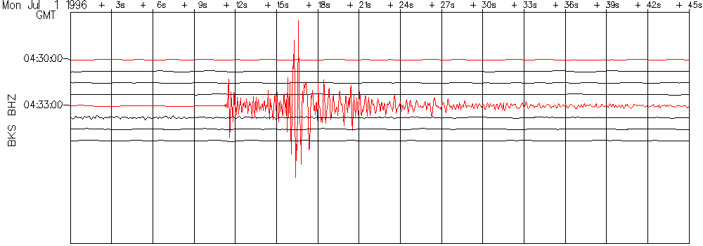
Based on the time scale shown on the plot, I can figure out the S-P time for this earthquake recorded at this station. In this case, the P wave arrives at 11.2 seconds after 04:33, and the S wave arrives at 15.8 seconds after 04:33. My S-P time is 4.6 seconds. Now, given a table which tells me how far away the earthquake is if I can tell the time difference, I find that the earthquake is about 36 km from BKS. (If you ever have a homework problem on this subject, you certainly can expect me to give you such a table, even though I don't show one here...)
Below are seismograms from three more sites in northern California, BRIB, JRSC, and MHC.
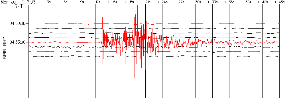
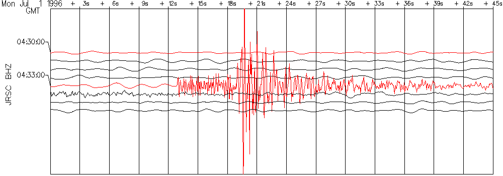
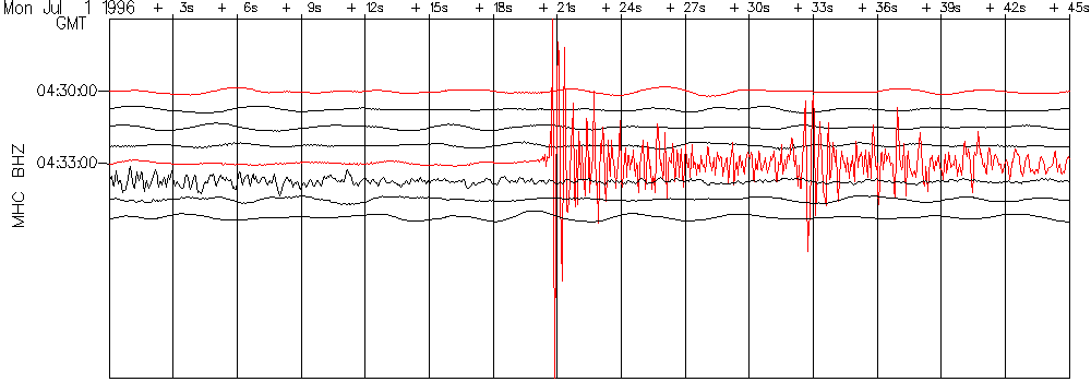
Following the same procedures to get S-P time and distance for these stations that I did for BKS, I can make the following table:
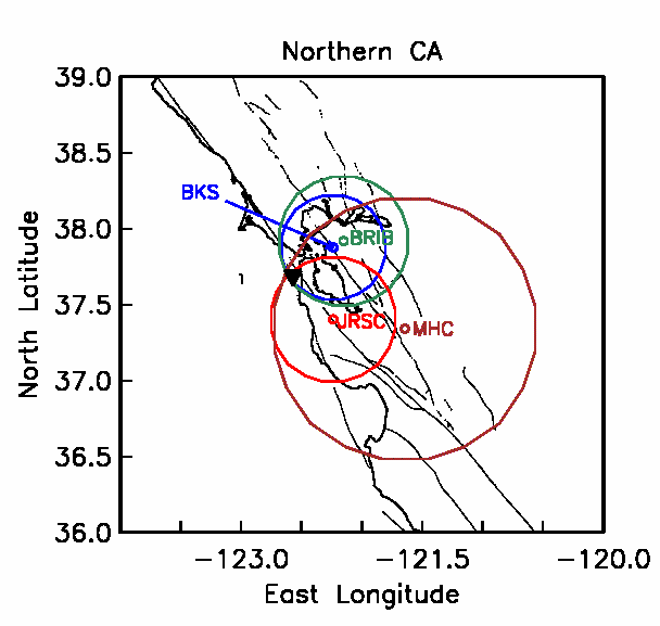
Now that I have my distances, I can get out my map of northern California, locate the stations on it, and draw circles of the appropriate radius (given the correct map scale, of course). My estimate of the location of the earthquake is the point where the circles intersect. I have marked the location that UC Berkeley finally settled on (using much more data than I have) with an inverted triangle -- you can see that the two locations are not much different.
Of course, these days nobody really locates earthquakes as I have just shown. Earthquakes are now located using computers and models of the structure of the Earth's crust in a given region. With digital recording, a skilled human operator, and good models of the crustal structure, locations can be found which are accurate to within about 250-500 meters.
Please note: you will have a homework problem on this later!
Note that the US Geological Survey's National Earthquake Information Center has a very nice web page on different ways to measure earthquakes. I certainly recommend reading it in addition to what I have to say below!
Most people living in California have heard about the ``Richter Scale'' and have at least a vague idea that it is used to measure the sizes of earthquakes. Most people that I know, though, have some misconceptions about the Richter Scale -- for example, someone once asked me if he could see where I kept my Richter Scale! Also, there are some important differences between magnitude, energy, and intensity that need to be discussed.
C.F. Richter at Caltech invented the idea of earthquake magnitudes in 1935 as a way to compare earthquakes. He was into astronomy and knew that astronomers used magnitude scales to compare the brightnesses of stars, so he adapted the idea for seismology. Richter based his scale on the way ground motion was recorded by a specific type of seismometer that was very common back in the 1930's, called a Wood-Anderson seismometer. It is very important for you to realize here that the Richter Scale is completely arbitrary; it was made up by Richter.
Basically, if you know how far away an earthquake is from your station, and you have a record from the earthquake, you can calculate its Richter magnitude. You do that by measuring the maximum amplitude of the shaking recorded by the W-A instrument, taking the logarithm of that amplitude, and adding in a number to take into account distance from the station. The key thing here is that the magnitude scale is logarithmic; for every one full point change in magnitude, the amount of shaking recorded by a seismometer will go up by a factor of 10.
Richter magnitude is useful, but limited; it is only defined for local earthquakes. Other magnitude scales have been developed to handle earthquakes that are distant from the seismometer making a given magnitude estimate, and these have been made to give magnitudes which are basically similar to Richter magnitudes. However, all of these scales have the same two fatal flaws. First, all of them become inaccurate at large magnitudes, and in fact, above about magnitude 8 or so, the magnitudes just don't get bigger (even though the earthquakes do). Second, these magnitude scales are all empirical; they don't actually tell you anything about the physics of the earthquake itself.
Recently, a new magnitude scale has been developed which has neither of these flaws: the moment magnitude scale. Unlike all the other kinds of magnitude, moment magnitude tells you something about the physical size of the earthquake. Moment magnitude really is physically meaningful. Also, moment magnitude is never overwhelmed by large earthquakes, and so it is possible to get meaningful estimates of magnitude even for humungous quakes. As an example of this, recently people have gone back and recomputed magnitudes for earthquakes such as the 1964 Alaska earthquake. Previously, the magnitude had been given as 8.6 - pretty damn big, but nothing compared to the 9.2 which is now accepted (remember that magnitude scales are logarithmic). Moment magnitudes are now the accepted magnitude among seismologists, and are usually the numbers given to the press.
Another way of looking at the size of earthquakes is to figure out how much energy they release. Some rules of thumb have been found to compare magnitude to energy, and it has been found that for each one point magnitude increase (say from a 4 to a 5), 32 times as much energy is released. If one jumps from a 5 to a 8, the energy goes up by 32 x 32 x 32, which is almost a factor of 33,000 -- but don't worry. While the total energy goes up that much, it does so not because the ground shakes 33,000 times harder, but instead because large earthquakes release energy for much longer and over a much wider area than do smaller earthquakes.
Finally, there is another way of looking at the strength of earthquakes, which depends not on records of earthquakes but on how the earthquake was perceived by people and how much damage is done. This is called intensity, and is described using the so-called Modified Mercalli Scale. (As a sidelight, Roger Musson from the Global Seismology and Geomagnetism Group of the British Geological Survey has assembled an interesting history of the "Mercalli Scale", mainly saying why it's not really the Modified Mercalli Scale). While there will be very little variation in magnitude estimates for a given earthquake, intensity measurements can (and do) vary widely. Intensities vary based on the distance from the earthquake, what the person making an intensity report was doing at the time of the earthquake (intensity would be lower from someone who was air-guitaring to Van Halen than from someone sitting quietly playing a viola, for example), by what kind of building they were in, what kind of soil they were on, etc. Intensities are inherently subjective, but can be of use to engineers who try to build earthquake-resistant buildings, for example.
How big can an earthquake get? Unfortunately, I can't give you a simple answer here. The maximum magnitude earthquake that a given fault can generate is determined by a number of factors. A long fault can generate a larger earthquake than a short fault, all other things being equal. A fault which tends to break and have the rocks jump farther than another fault will tend to generate larger earthquakes than that other fault. And the strength of the rocks is another factor: stronger rocks will tend to hold out longer, and generally break in a larger earthquake, than will weaker rocks.
I'm not sure how big the theoretical maximum size earthquake is period, but I can tell you that the largest earthquake ever recorded was in Chile, on 22 May 1960. It had a moment magnitude of 9.6, broke an area of fault 850 kilometers long and more than 120 kilometers wide, and generated a lot of damage and a humungous (taller than 30 feet in some places along the Chilean coast) tsunami. This earthquake released about as much energy as would be released by blowing up one billion tons of TNT!
At the other end of things, there is no limit to how small earthquakes can get. The instrumental limit is that, in the quietest locations with the most sensitive seismometers and earthquakes extremely near to the seismometer, it is possible to record earthquakes as small as magnitude -2. An earthquake that small would rupture a circular fault roughly 7 centimeters across and move it about 1 centimeter -- a tiny, tiny, tiny earthquake.
People generally stop feeling earthquakes when they drop below about magnitude 3 or so, although I know of a case where a magnitude 2.3 earthquake was felt by someone sitting very quietly in a house which was right on top of the epicenter.
Just as an aside, there was a great earthquake (magnitude 8.2) in Bolivia in 1994 at a depth of about 630 kilometers which was actually felt in North America. The earthquake was felt in high-rise buildings as far away as Renton, Washington -- which is almost 8700 kilometers from the epicenter! This is the greatest distance over which any earthquake is known to have been felt anywhere in the world.
Earthquakes happen constantly around the world. In an average year, there might be 20-25 magnitude 7 earthquakes globally -- about one every 2 to 3 weeks. On the other end of the magnitude scale, there are literally hundreds of thousands of tiny earthquakes worldwide in a given year.
Here's a little table with worldwide average rates:
| Magnitude | Description | Number in 1 Year | One Quake Every... |
|---|---|---|---|
| 8+ | Great | < 1 | 1--2 years |
| 7.0-7.9 | Major | 20ish | 2-3 weeks |
| 6.0-6.9 | Large | 120 | 3 days |
| 5.0-5.9 | Strong | 1,000 | 9 hours |
| 4.0-4.9 | Moderate | 6,000 | 90 minutes |
| 3.0-3.9 | Mild | 49,000 | 11 minutes |
| 2.0-2.9 | Small | 300,000 | 2 minutes |
| below 2 | Teeny Tiny | 600,000+ | 52 seconds |
Plate tectonics explains things about earthquakes that are not easily explainable otherwise. Here are a few:
More than 95% of the world's earthquakes occur in discrete belts throughout the world. The existence of these belts is one piece of evidence in support of plate tectonics. In fact, we now know these belts are plate boundaries. Earthquakes occur along all types of plate boundaries: subduction zones, transform faults, and spreading centers.
However, there are earthquakes which occur within plates. For example, the New Madrid area of Missouri (1811-1812), Charleston, South Carolina (1889), Boston (1755), and Hawaii (1975) are all places which have large earthquakes. In fact, in 1811-12 there were four very large earthquakes in the New Madrid area, which are believed to have been in the low magnitude 8 range (there are no actual recordings from which to figure out magnitudes...). These earthquakes actually rang church bells in Boston -- over 1700 kilometers away! -- and caused damage as far away as Washington D.C, more than 1100 kilometers away. There are also stories that say these earthquakes made the Mississippi River flow backwards for a short time!
Earthquakes which occur within plates (intraplate earthquakes) are among the remaining mysteries for plate tectonics, because plate tectonics cannot strictly explain their occurrence. In some places, such as Hawaii, the earthquakes are related to volcanism, but for the most part, intraplate earthquakes are as yet not fully understood.
Here's a map of earthquakes globally over the past five years, generated using the Seismic Monitor tool from the Incorporated Research Institutions for Seismology (IRIS). As you can see, most earthquakes are at plate boundaries, but there are some intraplate earthquakes. This map is up to date as of 2 February 1997 4:04:13 PM PST.
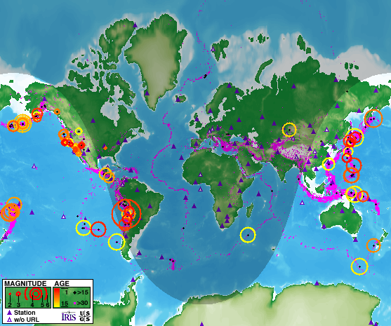
To generate a new map for yourself, use this web page and click on the Seismic Monitor button. The new map will be at most 30 minutes old.
These regions were known certainly by the early 1930's, but were not explained by then current ideas. It was only after the development of plate tectonics, which stated that plates were subducting into the mantle at deep trenches, that these zones could be explained. Keep in mind that these earthquakes are happening at depths far beyond the maximum depth at which the rocks are cool enough to support earthquake fractures. During the development of plate tectonics, deep and moderate-depth earthquakes were found to be located inside subducting slabs, which are much cooler than the rocks around them and can support rupture during earthquakes.
It is worth noting, however, that the cause of deep earthquakes is still being debated even today.
Earthquakes generate seismic waves, which can travel great distances through the earth. From these seismic waves, scientists can infer the structure of the earth on a global scale. We discussed earth structure in previous lectures, so I won't dwell on it here. I will simply give you a brief listing of some of what I think are the most interesting bits in global seismology.
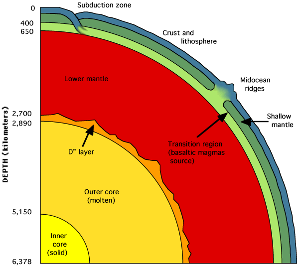
You know the earth is divided into (basically) the crust, mantle, outer and inner core, like the following figure:
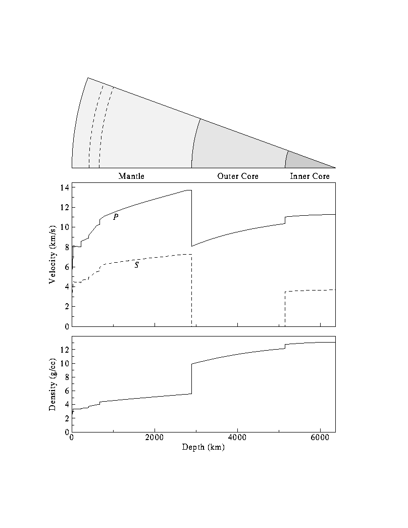
We infer this structure from many thousands of measurements of the time it takes seismic waves to travel around the world from various earthquakes. These data can tell us the seismic wave velocity and (remember the formulae for wave speed) the density at various points in the earth, and other data are combined with that to make the model we have of the inside of the Earth. Here's another model, which shows velocity and density as well. (Thanks to Peter Shearer for this figure.)
OK, so the basic radial earth structure is known. Now the most active parts of research lie in looking for variations in the properties of the Earth in all three dimensions, not just in distance out from the center. Among the areas which draw lots of attention are
That's Greg's brief and biased look at global seismology.
Here is a list of fundamental questions about large-scale seismology that are not yet answered, at least not to my knowledge:
There are many others, but these are my questions...
Greg Anderson