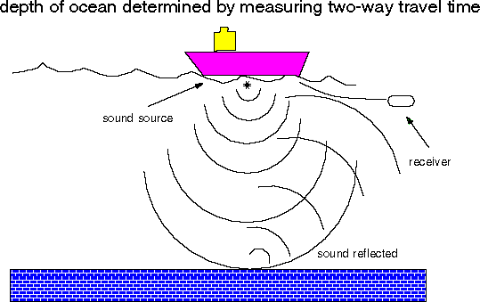
The shape of the ocean basins has been known vaguely since the expedition of the Challenger over 100 years ago. In the 50's the shape was further defined by means of "pingers". The ship emits a sound at a particular frequency as shown here:
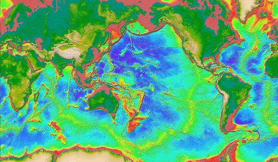
The sound reflects off the sea floor and the echo is "heard" by a receiver. The time it takes for the sound to travel down and back (the two-way travel time) can be converted into distance to the sea floor, provided the velocity of sound in water is known (which it is). Data collected in such a way led to the map shown in Figure 17.26 in your text. The artist, Marie Tharp, and her friend the oceanography, Bruce Heezen, drew the picture from a series of depth measurements obtained on a number of cruises. Nowadays, we can use gravity data measured by satellites to get a much higher resolution picture of the bathymetry (depth) of the ocean as seen in the famous "Sandwell map":
Taking an imaginary tour through the depths of the Atlantic ocean, we step off the beach in Florida and head for Africa.

 Full Size: 800x650,~230 Kbyte
Numerous, deep submarine canyons cut by subsea avalanches occur off New
Jersey, Delaware and Maryland. Click on image to view at full size.
Full Size: 800x650,~230 Kbyte
Numerous, deep submarine canyons cut by subsea avalanches occur off New
Jersey, Delaware and Maryland. Click on image to view at full size.
 Full Size: 800x650,~270 Kbyte
A seascape of plateaus and canyons reach out from theCalifornian coast where
the North American Plate is sliding past the Pacific Plate along a complex
system of faults, including the San Andreas Fault. Click on image to view at
full size.
Full Size: 800x650,~270 Kbyte
A seascape of plateaus and canyons reach out from theCalifornian coast where
the North American Plate is sliding past the Pacific Plate along a complex
system of faults, including the San Andreas Fault. Click on image to view at
full size.
The continental rise gives way to the abyssal plain that is some 4 to 6 km deep. The plain is punctuated by underwater volcanoes called seamounts. Seamounts often begin life as emergent volcanoes (e.g. The Azores), which depending on their location can be covered with coral reefs (e.g. the Bahamas). As the lithosphere supporting them cools, they submerge. The eroded top makes them "flat-topped" and these seamounts are called guyots. Atols are volcanic edifices about to become completely submerged, whose coral reefs are desparately trying to keep their heads in the light, forming a living ring of reef, around an already submerged volcano.
In the middle of the Atlantic is the spreading center at which Atlantic crust is formed by the separation of the Americas from Africa and Europe. This long chain of mountains is called the Mid-Atlantic ridge. On the East side of the ridge, the same sequence occurs in mirror image (apart from anomalies like the Azores) and we finally step onto dry land again at Gibraltar.
The Pacific profile is somewhat different from the Atlantic profile. The margin of Australia has no surprises, but the Tonga trench is unlike any feature encountered on our Atlantic tour (although if we had chosen to walk from Puerto Rico instead of from New England, we would have seen something similar - the Puerto Rico Trench). From our lectures on Plate Tectonics, you have probably guessed that the trenches are sites of subduction. Here the oceanic lithosphere is gobbled up by the deeper mantle and begins the grand planetary recycling scheme that distinguishes Earth from her sisters.

Ocean crust is formed at spreading centers. There is at least an intermittant magma chamber under the ridge that supplies melt to the surface. The magma ravels up to the top through feeder dikes and erupts as lava flows onto the sea floor. Rapid chilling of the magma by the very cold (2 degree C) water results in the water forming looping tube shaped lava flows reminiscent of intestines. These when viewed in profile, look like large "pillows" and such lava flows are often called pillow lavas. The crystallized magma chamber results in a layer of gabbro, the magma sheets chill to form a dike layer and the pillow lavas pile up to form a layer of pillows. With time the crust acquires a blanket of sediment on top, completing the crustal stratigraphy. Underneath this layer of new crust is the depleted mantle, the remaining material after partial melting to supply the magma for the overlying crust.
And finally we get to the wet stuff - the ocean. Later in the course, we will get to the beach/wave part. Now we will be concerned with the "blue water" ocean. The main thing about oceans is that the water is in constant motion. There are large currents in the ocean, both in map view and vertically as well. This "stirring" is extremely important to us humans as we shall see.
There are two major sources of energy for driving ocean currents: the sun (via wind) and density (via salt content and temperture). First we will consider the force of the winds.
The source of energy for wind is the heat from the sun. The sun warms the air in the topics. This creates a temperature difference between the equator and the pole and of course the air "wants" to even things out. In fact, this tendency is a fundamental law of physics. Thus, heat will always flow from warmer to cooler regions and the air attempts to do this too. Another fundamental law of physics is that things once started moving, will travel in straight lines. This is impossible on the surface of a globe, but the air does the best it can, tracing out what appears to be a curve on the surface of the globe. Also, since the Earth is rotating we have a third law of physics and that is that "angular momentum is conserved". This is the same reason that a skater twirls faster as her arms are brought closer to her body. In a nutshell, things bend to the right in the northern hemisphere and to the left in the southern hemisphere.
Here is a nice link explaining the coriolis force:
http://covis2.atmos.uiuc.edu/guide/forces/html/coriolis.html
Finally, warm air rises. This is because the air molecules have more energy, and bounce harder against one another, causing the air mass to expand. There is less mass per unit volume; hence the air is less dense and rises. The upshot of all this physics is that air rises at the equator and is replaced by air from the surrounding material. This makes the northeast (bending to the right (southwest) as it comes from the north) and southeast trades (bending to the left (northwest as it comes from the south). Check out Figure 14.1 in your book and admire the pretty picture below.

Now how does wind drive water. It is simple - it pushes it! However, water also is affected by the coriolis force and so the great ocean currents are big circles. And here they are:

The other main driving force for ocean currents is density. When water gets saltier and colder, it gets denser and sinks. A good way to make really dense water it to form ice. It happens when water is good and cold and the ice preferentially excludes salt, so the remaining water gets saltier. If the water gets cold enough and salty enough, it sinks right to the bottom. [Ice of course floats, so there is a density maximum at some temperature just above freezing]. The deep water then travels along the ocean floor in great currents:

Water returns to the surface in places called upwelling zones where water is being displaced by the action of winds (for example over the equator and along the California coast).
If there were no way for the deep water to return to the surface, the surface ocean would run out of nutrients and everything would die. Then we would die, because plants in the sea are the primary source of oxygen in the atmosphere. We also would have no more fish and chips!
Fortunately, because of the kindly action of wind, water circulates in the ocean and there are regions of upwelling. Referreing to the picture above, you will notice that these regions (marked by XXX's) are also the major regions of fishing. (see also this link about modelling of winds and ocean currents)
http://www.acl.lanl.gov/GrandChal/GCM/gcm.html
Lisa Tauxe