One question lots of people ask me is: ``How do you locate an earthquake?'' It turns out that, while the procedure is not entirely straightforward, it is not all that difficult to locate an earthquake. I'll tell you how we locate local earthquakes; distant earthquakes are located using similar methods, but they are a bit more complicated than we need to worry about.
You will recall from the discussion in Section 3 that there are three major kinds of seismic waves: P, S, and surface waves. P waves travel faster through the Earth than do S waves, so P waves arrive before S waves do. If you have a seismogram, and you know how to measure time accurately on it, you can pick the arrival times of the P wave and the S wave. Next, you figure out how far apart these waves arrive, called the S-P time. You can then go to a table of distance as a function of S-P time and work out how far away the earthquake was from your station. If you have three or more stations, you can draw circles on a map, and where the circles meet is the location of your earthquake. Essentially, you are triangulating the earthquake's location.
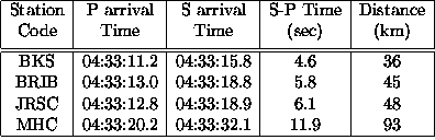
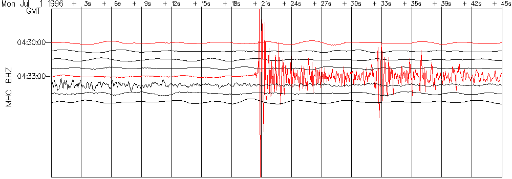
An example is probably useful. Below, you will see a seismogram from a seismometer in northern California called BKS. You should see an earthquake recording (the squiggly line), and specifically note that there are two points in the record at which the size of the signal (what seismologists call the amplitude) jumps fairly strongly. The first jump is the arrival of the P wave, and the second major jump (although in this case, it's actually a major drop) is the arrival of the S wave.
Based on the time scale shown on the plot, I can figure out the S-P time for this earthquake recorded at this station. In this case, the P wave arrives at 11.2 seconds after 04:33, and the S wave arrives at 15.8 seconds after 04:33. My S-P time is 4.6 seconds. Now, given a table which tells me how far away the earthquake is if I can tell the time difference, I find that the earthquake is about 36 km from BKS. (If you ever have a homework problem on this subject, you certainly can expect me to give you such a table, even though I don't show one here...)
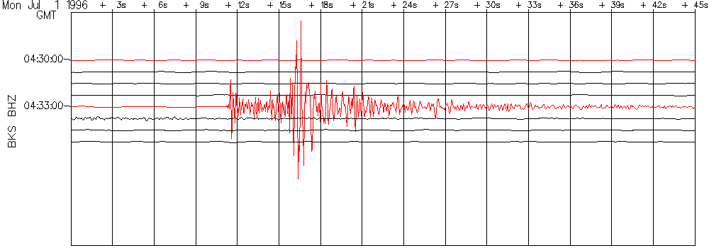
Below are seismograms from three more sites in northern California, BRIB, JRSC, and MHC.
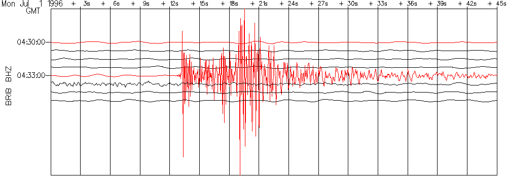
Following the same procedures to get S-P time and distance for these stations that I did for BKS, I can make the following table:
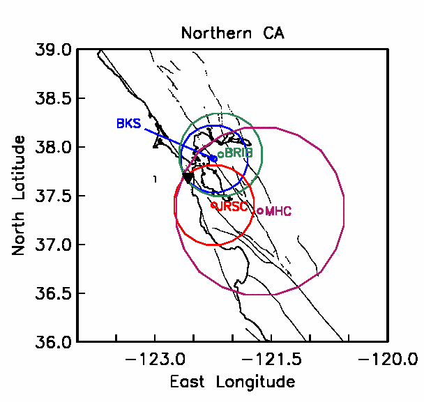
Now that I have my distances, I can get out my map of northern California, locate the stations on it, and draw circles of the appropriate radius (given the correct map scale, of course). My estimate of the location of the earthquake is the point where the circles intersect. I have marked the location that UC Berkeley finally settled on (using much more data than I have) with an inverted triangle -- you can see that the two locations are not much different.
Of course, these days nobody really locates earthquakes as I have just shown. Earthquakes are now located using computers and models of the structure of the Earth's crust in a given region. With digital recording, a skilled human operator, and good models of the crustal structure, locations can be found which are accurate to within about 250-500 meters.
Greg Anderson