
Copyright 1996, David T. Sandwell
We are constructing a complete bathymetric map of the oceans at a 3-10 km resolution by combining all of the available depth soundings collected over the past 30 years with high resolution marine gravity information provided by the Geosat, ERS-1/2, and Topex/Poseidon altimeters. Detailed bathymetry is essential for understanding physical oceanography and marine geophysics. Currents and tides are controlled by the overall shapes of the ocean basins as well as the smaller sharp ocean ridges and seamounts. Because erosion rates are low in the deep oceans, detailed bathymetry reveals the mantle convection patterns, the plate boundaries, the cooling/subsidence of the oceanic lithosphere, the oceanic plateaus, and the distribution of off-ridge volcanoes. Current global digital bathymetry maps (e.g. ETOPO-5) lack many important details such as a 400 km-long ridge that rises to within 135 m of sea level (Figure 1). Moreover, they are contaminated by long-wavelength errors (~2000 km) which prevent accurate identification of seafloor swells associated with mantle plumes [Smith, 1993].
The tasks include:
* Accumulate all available depth soundings collected
over the past 30 years. (funded by NSF)
* Use the short wavelength (< 160 km) satellite gravity information
to interpolate between sparse ship soundings.
* Improve the resolution of the marine gravity field using enhanced estimates
along repeat altimeter profiles together with the dense altimeter measurements.
* Refine/Improve bathymetric predictions using the improved resolution
gravity field and also by investigating computer-intensive methods for
bathymetric prediction such as inverse theory.
* Produce a Globe of the Earth similar to the globe of Venus prepared
by the NASA Magellan investigation. This will also include the best available
digital land data.
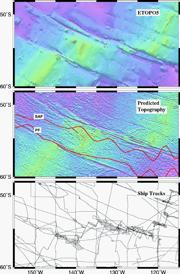
Figure 1. (top) Seafloor depth based on ETOPO-5 lacks
the topographic expression of a 400 km long ridge as well as the rugged
topography of the Eltanin and Udintsev Fracture Zone Systems. The ridge
(53S, 140W, minumum depth 135 m) was first surveyed by a French expedition
in December of 1995. These topographic features effect the flow of the
the Antarctic Circumploar Current.
(middle) Predicted seafloor depth based on ship soundings and declassified
Geosat/GM data. The Sub-Antarctic Front (SAF-red) [Gille, 1994]
passes directly over the NW-trending ridge. The Polar Front (PF) is centered
on the 6000m deep valley of the Udintsev transform fault.
(bottom) Ship soundings used in the bathymetric prediction. Predicted depths
are constrained to agree with measured depths along these tracklines.
Smith, W. H. F. and D. T. Sandwell, Bathymetric prediction from dense satellite altimetry and sparse shipboard bathymetry, J. Geophys. Res., 99, 21803-21824, 1994.
Sandwell, D. T. and W. H. F. Smith, Marine Gravity from Geosat and ERS-1 Altimetry, J. Geophys. Res., in press (anonymous ftp baltica.ucsd.edu).
A detailed knowledge of topography is fundamental to the understanding of most earth processes. On the land, weather and climate are controlled by topography on scales ranging from large continental land masses to small mountain valleys. The land is shaped by tectonics, erosion, and sedimentation and thus detailed topography is an essential component of any geological investigation. Hydrogeologic and biological processes are also largely controlled by local relief. The planned Shuttle mission to map land topography at 30 m horizontal resolution will provide much of the detailed information for land studies.
In the Oceans, detailed bathymetry is also essential for understanding physical oceanography and marine geophysics. Currents and tides are controlled by the overall shapes of the ocean basins as well as the smaller sharp ocean ridges and seamounts (Figure 1). Because erosion and sedimentation rates are low in the deep oceans, detailed bathymetry reveals the mantle convection patterns, the plate boundaries, the cooling/subsidence of the oceanic lithosphere, the oceanic plateaus, and the distribution of off-ridge volcanoes. Finally biological processes are largely controlled by ocean depth and terrain. In contrast to the Shuttle mission which can recover the land topography in 10 days, it would take approximatelt 125 ship-years to map the ocean basins at a 100 m horizontal resolution. Here we propose to map the topography of the ocean basins at a 3-10 km resolution using data collected by satellite altimeters and shipborn echo sounders. This is a diverse effort that is currently partly funded by the Marine Geology and Geophysics Division Program at NSF and was partly funded under the NASA Global Geodynamics Program.
Now is the time to undertake this bathymetric mapping because radar altimeters aboard the ERS-1/2, Geosat, and Topex/Poseidon spacecraft have surveyed the marine gravity field over nearly all of the world's oceans to a high accuracy and spatial resolution. On March 15, 1995 ERS-1 completed its dense mapping (~8 km track spacing at equator) of the marine gravity between latitudes of +81.5. On July 28, 1995 all of the Geosat altimeter data were declassified (~4 km track spacing at the equator; latitudes between +72). Moreover, the Topex/Poseidon altimeter has accumulated many years of data having exceptional quality. With NASA and other funding we have assimilated most of these data into a global marine gravity anomaly grid (Figure 2) [Sandwell and Smith, 1996].
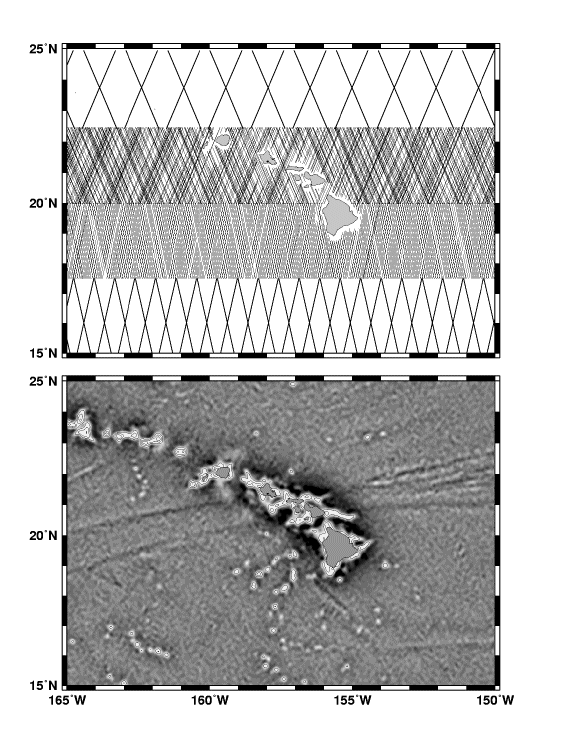
Figure 2 (top) Tracks of stacked Geosat/ERM (17-day repeat cycle) (22.5-25 N), Geosat/GM (20-22.5 N), ERS-1 Geodetic Phase (168-day repeat cycle) (17.5-20 N) and stacked ERS-1 (35-day repeat) (15-17.5N). (bottom) Vertical gravity gradient (i.e., curvature of ocean surface) around Hawaii derived from all 4 data sets. Contours at 50 and 100 Eotvos units are shown to highlight seamount/island signatures.
In the wavelength band 15 to 200 km, variations in gravity anomaly are highly correlated with seafloor topography. Since many southern ocean areas and some northern ocean areas are sparsely surveyed, these new satellite altimeter data reveal many previously unsurveyed features such as ridge axes, seamounts and fracture zones.
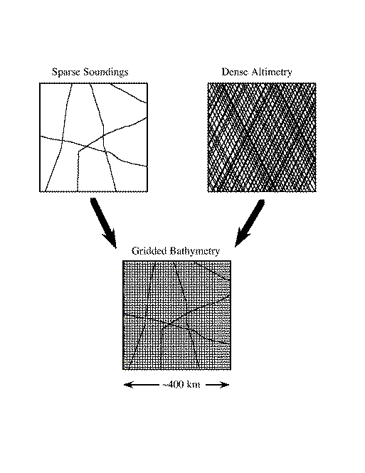
The conceptual approach is to use the sparse depth soundings to constrain the long-wavelength depth while the shorter-wavelength topography is predicted from the downward-continued satellite gravity measurements [Smith and Sandwell, 1994]. Over the short wavelength band, the topography/gravity ratio is regionally calibrated using available soundings. We have found that major errors in the ETOPO-5 bathymetric model make it unsuitable for either constraining the long-wavelength depths or for calibrating the topography/gravity ratio. Thus for an accurate prediction, it is essential to go back to the raw ship soundings.


| Good | Bad | |
|---|---|---|
| WS | 2185 | 564 |
| SIO | 1415 | 182 |
| NGDC | 1253 | 813 |
| BB | 125 | 848 |
WS - Wessel Smith data base which is a derivative of the
original Lamont Data base.
SIO - Scripps data base, Geological Data Center.
NGDC - National Geophysical Data Center data base.
BB - Brownbook derivative of Lamont data base.
(WS and BB have some identical data so WS is searched first.)
The automation, maintenance, and rescue of the ship data is largely funded by the NSF Division of Ocean Sciences. In addition to these data we are preparing for the possible declassification of a the US Navy Ocean Survey data [Medea Report, 1995].
Data preparation and assembly is an ongoing process; the current data are sufficiently good to construct a global bathymetric grid. Here is one recipe (Nettleton's Method) that we are developing.
1) Grid available bathymetric soundings on a 2 minute Mercator grid that matches our gravity anomaly grid. To avoid seams, all work is done on a global grid between latitudes of +72deg. Coastline points from GMT provide the zero-depth estimates. A finite-difference, minimum-curvature routine is used to interpolate the global grid [Smith and Wessel, 1990]. This gridding program requires at least 256 Mbytes of computer memory.
2) Separate the grid into low-pass and high-pass components using a Gaussian filter (0.5 gain at 160 km). Filtering and downward continuation are performed with a multiple strip, 2-D FFT that spans 0-360deg longitude to avoid Greenwich edge effects.
3) Form high-pass filtered gravity using the same Gaussian filter.
4) Downward continue the high-pass filtered gravity to the low-pass filtered bathymetry assuming Laplace's equation is appropriate. A depth-dependent Wiener filter is used to stabilize the downward continuation.
5) Accumulate high-pass filtered soundings and corresponding high-pass filtered/downward-continued gravity into small (160 km) overlapping areas and perform a robust regression analysis. In sediment-free areas, the topography/gravity transfer function should be flat and equal to 1/2[pi]G[Delta][rho] so in the space domain, a linear regression is appropriate. This works well on young seafloor but not on old seafloor where sediment cover destroys the correlation between topography and gravity. In these cases we assume the seafloor is flat and set the topography/gravity ratio to zero. Finally there are intermediate cases where topographic depressions will be sediment filled while the highs protrude above the sediments so the topography/gravity relationship is non-linear. It is these partially sedimented areas that make the bathymetric problem difficult and inherently non-linear. Continental margins and shelves pose similar problems.
6) Regional topography/gravity ratio estimates are gridded and multiplied by the high-pass filtered/downward-continued gravity to form high-pass filtered predicted bathymetry.
7) The total predicted bathymetry is equal to the sum of the high-pass filtered predicted bathymetry and the low-pass filtered bathymetry.
8) Finally, the pixels constrained by ship soundings or coastline data are reset to the measured values and the finite-difference, minimum curvature routine is used to perturb the predicted values toward the measured values. Measured depths are flagged so they can be extracted separately. This final step dramatically increases the accuracy and resolution of the bathymetric grid in well surveyed areas so it agrees with the best hand-contoured bathymetric charts.