


Next: Faults in the Wild
Up: ES 10 Lecture
Previous: ES 10 Lecture
I have to admit from the beginning that I'm not a geologist, so I may well
make a mistake or two in this section. I apologize in advance for any
such problems you might find. If you do find one, please send me e-mail so
that I can fix it.
Very little of what is now California was originally a part of North America
back in the Precambrian Era; basically the Mojave Desert basement rocks were
around then. Most of the rest of California is made up of large chunks of
different kinds of rocks which were ``imported'' from other parts of the
world through plate tectonic movements. These big chunks of rock are called
displaced terranes.
California is an amazing mess of such terranes, and doing a good job of giving
the full history of these terranes would certainly take a full book. So I'm
not even going to try. Instead, I'll give a brief timeline in list form, with
the main highlights of California's evolution outlined. At the end of this
section, I'll try to list some other good references to look at for more
detailed information. For reference, ``Ma'' means ``million years ago''.
- Precambrian time (2,000-540 Ma)
- Outcrops in the Mojave Desert, San Bernardino and San Gabriel
Mountains.
- Oldest rocks in California, about 1,800-2,000 million years
old.
- Early to Mid-Palaeozoic/Cambrian to Mid-Devonian (540-400 Ma):
- West coast very similar to East coast today.
- Passive continental margin with no subduction.
- Rocks from this age are found in the Inyo Mountains of
eastern California and in the Great Basin area.
- Mid-Palaeozoic to Early Mesozoic/Mid-Devonian to early Triassic
(400-240 Ma):
- Transition from a passive continental margin to a subduction
zone.
- Island arc volcanism and thrusting of continental shelf
deposits from earlier passive margin.
- Accretion of various displaced terranes.
- Island arcs, ophiolites, and mélanges accreted to form
ancestral Klamath Mountains and Sierra Nevada.
- Rocks from this age form roof pendants (sort of a
giant hat) over later batholiths. The pendants are
found in the Sierra near Convict Lake, among other places.
Also form much of the Basin and Range province.
- Early Mesozoic/Mid-Triassic (240-215 Ma):
- Spreading center hits continental boundary.
- The Foothill suture zone (west side of Sierra) forms.
- Mesozoic to Mid-Cenozoic/Late Triassic to Mid-Oligocene (210-30 Ma):
- Farallon Plate subducts under W coast of North America
- Central Valley is a forearc basin, gets filled with
submarine sediments and turbidites from ancestral Sierra Nevada.
- Great Valley sequence (forearc basin sediments) accreted
- Coast Range Ophiolite (ophiolites are believed to be
chunks of ocean floor) squished onto the underside leading edge
of the North American Plate (a process called
underplating).
- Franciscan sequence (a huge mess of multiple terranes)
is underplated
- Sierra Nevada and Peninsular Range batholiths are formed.
Peninsular Range mountains are Baja and San Jacintos, etc.
- Salinian block formed. Either formed in its present location
(west-central CA) or formed much farther away.
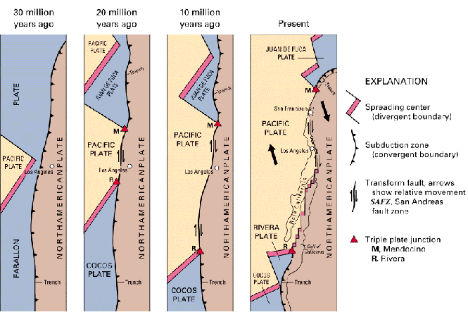
- Oligocene (30 Ma):
- Farallon-Pacific spreading center hits coast
- Triple junctions form. One migrates north (Mendocino TJ) and
other south (Rivera TJ).
- Ancestral San Andreas Fault forms
- Miocene (10-5 Ma):
- Rivera TJ jumps inland, perhaps several times
- This might create several faults in southern California
(i.e. Elsinore)
- Miocene-Pliocene (5 Ma):
- Gulf of California opens
- Big Bend in SAF forms
- Los Angeles, Santa Barbara, and Ventura Basins form, fill in
with sediments.
- Uplift of mountains north of Los Angeles
- Mid-Pliocene (2 Ma):
- Southernmost SAF forms in ``present'' position
- Pleistocene-Present (1.6-0 Ma):
- Ice Ages
- Humungous lakes form, such as Lake Bonneville (the much much
bigger version of the Great Salt Lake), Lake Lahontan (which
contained what are now Honey Lake, Walker Lake, Pyramid Lake
and the Carson Sink in Nevada, among other things), and Lake
Cahuilla (the much bigger
version of the Salton Sea). Then they shrink, and form, and
shrink, and form, and shrink...
- Glaciers in the Sierra
- Long Valley Caldera and other volcanism near Great Basin
Please keep in mind that this is an extremely bare-bones chronology and
no doubt I have left out lots of stuff.
Here's another list of odd or otherwise interesting facts I dug up in the
process of making the list above:
- Franciscan rocks have moved 2000 km (based on palaeomagnetism)
- Franciscan rocks make up both much of NW CA and Channel Is
- Coast Range ophiolite moved 2-4000 km (based on palaeomagnetism)
- Salinian block either part of Sierra or displaced terrane from
2500 km away
- Up to 560 km right-lateral slip on SAF (demonstrated by mismatched
rocks)
- LA Basin sediments up to 27000 feet (8300 meters) thick
Figure 1 is a nice picture from the USGS
which shows the last 30 million years of California's evolution.
Figure 1.
Schematic diagram showing the last 30 million years of evolution of the
California continental margin. From
USGS Professional Paper 1515.
Here are a couple places to look for more information. Both are fairly
technical.
- The Geotectonic Evolution of California, W.G. Ernst, editor.
Prentice-Hall, Englewood Cliffs, N.J. 1981
- The San Andreas Fault System, California, Robert E. Wallace,
editor. US Geological Survey Professional Paper 1515, 1990.
Next: Faults in the Wild
Up: ES 10 Lecture
Previous: ES 10 Lecture
Greg Anderson
ganderson@ucsd.edu
Wed Mar 19 00:10:13 PST 1997