ES10 - EARTH
Lecture 6- Isostasy and Plate Tectonics
David Sandwell
(Plate Tectonic notes by Lisa Tauxe)
A number of questions were posed in the last two lectures
but the following three were never answered:
How does the oceanic crust form?
Why don't continents subduct?
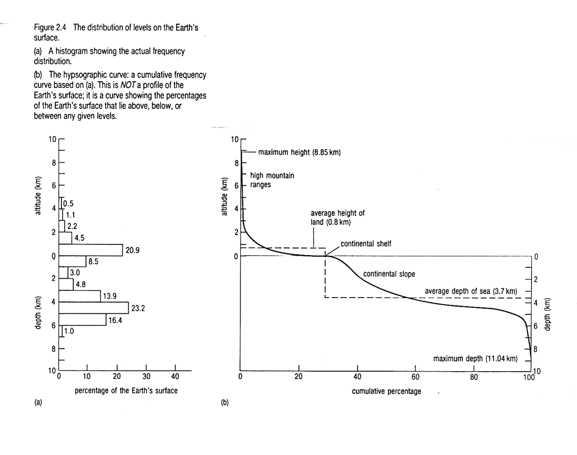
The histogram of elevation shows two peaks, why?
This first part of this lecture will answer these questions:
New questions:
How old is the oldest oceanic
crust and where is it located?
How old is the oldest continental crust?
What is a typical spreading rate?
What are two methods for measuring spreading rate?
What is a triple junction?
Actually I won't answer two of these questions this time
either but you can look in the book or wait for future lectures. The second
part of the lecture will be:
The Plate Tectonic Theory (notes by Lisa
Tauxe)
- The crust and outermost mantle form a thick (100 km) strong coat of
armor that floats on a weaker layer that may be partially molten. This
outer layer is called the lithosphere and the underlying soft layer
is the asthenosphere.
- The lithosphere is broken into a number of plates, that are
in constant motion with respect to one another. There are three types of
plate
boundaries. Where plates move apart is called a divergent boundary
and new oceanic crust is generated along ridges formed by chains
of submarine volcanoes. Where plates move toward one another is a convergent
boundary. There, one plate overrides the other. The down-going plate is
consumed at a subduction zone. This process also generates volcanoes
which form island or continental arcs. Places where plates slide
by one another are transform boundaries and zones of diffuse deformation
where the plate interactions are complicated are called plate boundary
zones - a fourth type of plate boundary.
- Plates move according to the rules of rotations on a sphere developed
by Euler.
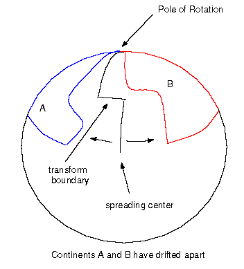
Imagine that you place your hands on a globe with your thumbs tucked
under your palms and your index fingers touching. Now move your hands apart
while keeping the tips of your index fingers in contact. Where your fingers
touch is the pole of rotation. Where your fingers were is the spreading
center. Note that the farther from the pole of rotation you are, the faster
your hands are moving in space, even though the angular rate of rotation
is constant.
- The grinding of the plates as they move with respect to one another
is the principal cause of earthquakes and indeed, most earthquakes are
located along plate boundaries:

- When new crust forms, it is hot. Therefore it is less dense,
more buoyant and it "sticks up" higher than the surrounding,
older colder material. This is why ridges are higher than the surrounding
crust. As the oceanic crust is pulled away from the spreading center, it
cools and sinks. Also, the farther from the spreading center, the older
the crust.
- The Earth's field is a great magnet which switches its polarity often
and without warning. As crust forms, it retains a record of the magnetic
field at the time. Thus, the ocean crust forms a gigantic tape recording
of the "music of the Earth":
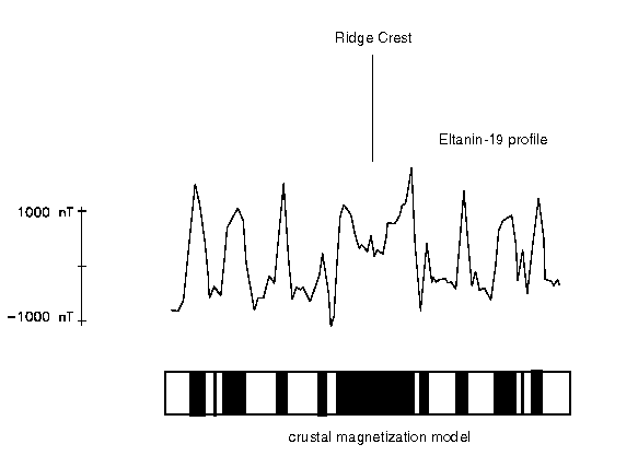
Formation of marine magnetic anomalies at a mid-ocean ridge. Black and
white parts of the oceanic crust (Layer 2) represent normal and reversed
magnetizations respectively. New lithosphere is created at the central
ridge and is spreads away. Crust acquires the magnetization of the prevailing
field and blocks of alternate polarity add or subtract from the ambient
Earth's magnetic field resulting in lineated stripes of anomalously high
and low values of the total magnetic field.
- The magnetic field averages to approximately the rotational axis of
the Earth. If one plots the location of the magnetic pole as viewed from
a continent that is drifting, that pole appears to move. Thus, the apparent
polar wander paths of continents record continental drift.
Evidence for the plate tectonic theory
The theory of plate tectonics as described above makes a number of testable
predictions. Here are a few:
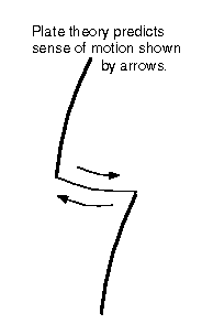
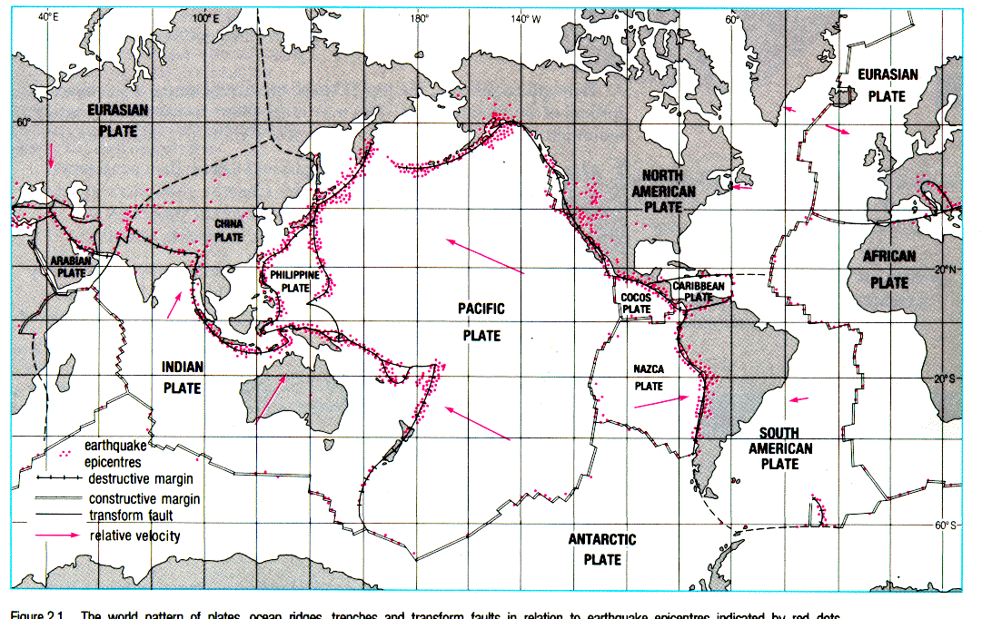
- Earthquakes.
- Data from earthquakes can be used to infer the sense of motion of the
plates involved. Plate tectonic theory predicts that the plates will slide
by one another as shown in the figure below. Without plate tectonics, you
might guess that the motion would be the other way!
Earthquakes also should mark where the subducting slab is penetrating
the mantle:
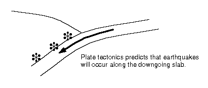
Earthquake data in fact strongly support the plate tectonic theory.
- Seafloor Bathymetry
- As already mentioned. The new crust is hot and buoyant and it sinks
as it cools. The actual depth of the ocean as a function of age can be
predicted very well from thermal models of a cooling slab in contact with
cold sea water.
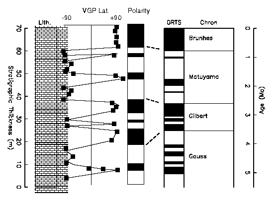
- Age of the oceans
- If the timing of the reversals of the magnetic field is known from
other sources, the age of the sea floor can be determined by matching of
the magnetic anomalies. These anomalies should match the reversal pattern
determined from sediments such as that shown here:
Here is a picture of the age of the sea floor as determined from magnetic
anomalies (by
Dietmar Müller): 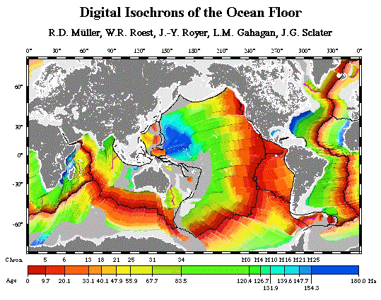
One could then go and drill the seafloor to check if the predicted ages
matched the observed ages. This has been done with the aid of research
drilling ships such as the JOIDES
Resolution and the agreement is excellent.
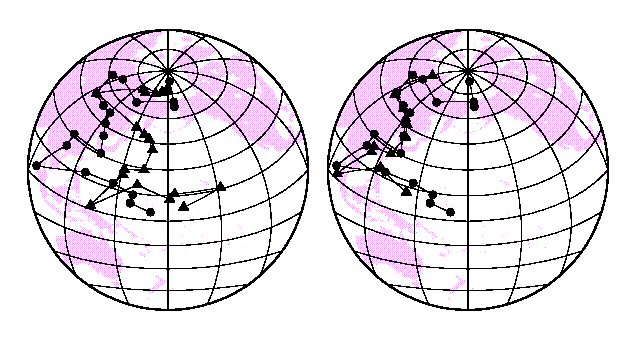
- Matching coastlines - matching APWP
- Many people have had an urge to put Africa and South America together
like pieces of a puzzle. If the idea of continental drift is correct, doing
so should line up the apparent polar wander paths (see above). Here are
the data and I think you will agree, that the APWP for North America and
Europe agree much better after the two have been slipped back together
(right diagram) than in their present coordinates (left).
- Other evidence
- In the early part of this century, a meteorologist named Wegener presented
a large body of evidence in support of continental drift. He proposed that
all the continents were once part of a single huge continent called Pangaea.
He noted among other things that fossils of plants and land animals that
could not travel across a huge ocean were similar on many of the continents
of Pangaea as shown here:

Please check out this
link for a great summary of continental drift.
Lisa Tauxe
ltauxe@ucsd.edu