InSAR/GPS Integration
 We
are integrating Interferometric Synthetic Aperture Radar (InSAR), continuous
Global Positioning System (CGPS) geodesy and ground-based GPS meteorology
(GPS Met) into a single geodetic instrument that will measure crustal deformation
to 1 mm/yr precision with unprecedented spatial coverage. If successful,
this instrument will be able to determine motion at millions of points,
rather than the few hundred being measured with current geodetic methods.
Our goal is to develop a technique to measure interseismic, coseismic,
and postseismic deformation, and, by relating these to seismicity and geological
structures, probe plate boundary kinematics (e.g., microplate tectonics
versus continuum tectonics; thick-skinned versus thin-skinned models).
Also, measuring the complete deformation field would be very valuable in
assessing earthquake hazard. Through our involvement in the Southern California
Earthquake Center we would be able to apply our results immediately.
We
are integrating Interferometric Synthetic Aperture Radar (InSAR), continuous
Global Positioning System (CGPS) geodesy and ground-based GPS meteorology
(GPS Met) into a single geodetic instrument that will measure crustal deformation
to 1 mm/yr precision with unprecedented spatial coverage. If successful,
this instrument will be able to determine motion at millions of points,
rather than the few hundred being measured with current geodetic methods.
Our goal is to develop a technique to measure interseismic, coseismic,
and postseismic deformation, and, by relating these to seismicity and geological
structures, probe plate boundary kinematics (e.g., microplate tectonics
versus continuum tectonics; thick-skinned versus thin-skinned models).
Also, measuring the complete deformation field would be very valuable in
assessing earthquake hazard. Through our involvement in the Southern California
Earthquake Center we would be able to apply our results immediately.
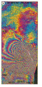 The
southwestern U.S. has already demonstrated to be an ideal location for
using INSAR methods to measure ground displacements. These applications
have so far been confined to coseismic and
postseismic motions. We propose to use SAR imagery collected by ERS-1/2,
JERS-1 and RADARSAT to measure interseismic motions with respect to the
southern California array of permanent GPS receivers. Our approach will
use the CGPS data to reduce two of the current error sources in determining
ground displacements with INSAR:
The
southwestern U.S. has already demonstrated to be an ideal location for
using INSAR methods to measure ground displacements. These applications
have so far been confined to coseismic and
postseismic motions. We propose to use SAR imagery collected by ERS-1/2,
JERS-1 and RADARSAT to measure interseismic motions with respect to the
southern California array of permanent GPS receivers. Our approach will
use the CGPS data to reduce two of the current error sources in determining
ground displacements with INSAR:
- the "baseline" or orbital errors. We will place
radar reflectors/transponders at some of the GPS sites. The SAR data covering
each of these points will thus correspond to a precisely-located point,
and so could be used to provide 3-D control on the spacecraft orbit and
improve the accuracy of the ground displacement measurement.
- troposphere propagation errors. We will use suitably
equipped continuous GPS stations, meteorological satellites, and regional-scale
mesoscale models to map the spatial and temporal distribution of water
vapor over southern California. Temporal variations in the horizontal gradients
of line-of-sight integrated water vapor, if not properly accounted for,
can produce artifacts in the radar displacement fields with magnitudes
~ 1 cm; our maps will allow us to correct for these errors.
In the first year, we will acquire at least six repeat
passes of a pair of ERS-1/2 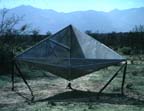 radar images covering the Los Angeles Basin and surroundings, taking advantage
of the dense concentration of CGPS sites. Deformation within the basin
is dominated by contraction at a rate of approximately 7 mm/yr and consequently
thrust faulting. We will construct 10 radar reflectors,deploy
them within the basin, and tie them precisely to the CGPS sites by GPS
survey. We will evaluate the efficacy of radar reflectors and investigate
the option of installing radio transponders. In the second year, will deploy
another 10 radar reflectors or radio transponders.
radar images covering the Los Angeles Basin and surroundings, taking advantage
of the dense concentration of CGPS sites. Deformation within the basin
is dominated by contraction at a rate of approximately 7 mm/yr and consequently
thrust faulting. We will construct 10 radar reflectors,deploy
them within the basin, and tie them precisely to the CGPS sites by GPS
survey. We will evaluate the efficacy of radar reflectors and investigate
the option of installing radio transponders. In the second year, will deploy
another 10 radar reflectors or radio transponders.
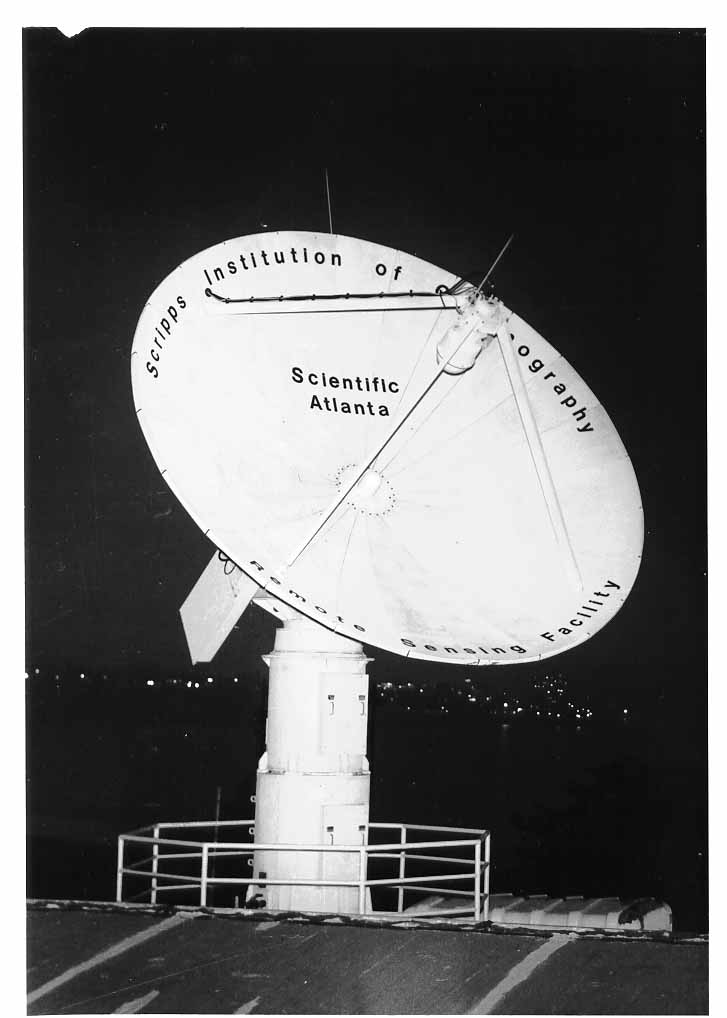
In the second and third years, we will acquire radar images
through the Scripps X-band down-link, also
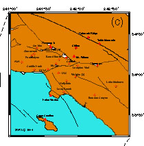
investigating the southern San Andreas fault, the San  Jacinto
fault, and the Salton trough where the number of continuous GPS stations
is lower but the deformation rate is higher and primarily dextral.
Jacinto
fault, and the Salton trough where the number of continuous GPS stations
is lower but the deformation rate is higher and primarily dextral.
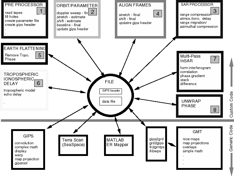
We are developing software
to convert raw radar echoes into single look complex (SLC) images and then
into geolocated and corrected interferograms. However, to routinely monitor
crustal deformation over large areas and utilize the ancillary information
provided by the CGPS array, radar reflectors/transponders, and meteorological
sensors will require a great deal of integration and automation. To achieve
our objectives, we have assembled investigators from several institutions,
who between them combine backgrounds in satellite geodesy/GPS, interferometric
SAR, GPS meteorology, satellite radar altimetry, earthquake seismology,
neotectonics and satellite data acquisition systems.