OK, so we're now back to stuff I feel more comfortable with, like: What is a fault? What kinds are there? How can faults be recognized ``in the wild''? And where are the faults in southern California? All good questions.
A fault is a crack in the ground which divides a single block of rock into two blocks of rock. However, what makes a fault a fault (as opposed to a joint) is that there is motion between the two blocks of rock. So a fault is a crack in rock which has relative motion between the blocks of rock on either side of the crack.
There are three basic kinds of faults: strike-slip, normal, and reverse. Normal and reverse faults are also lumped together and called ``dip-slip'' faults. Figure 2 (borrowed from Lisa Tauxe's notes) gives a simplish diagram of each of these three kinds of faults.
Combinations of these basic kinds of faults are possible, making what are called oblique-slip faults.
Strike-slip faults come in two flavors as do dip-slip faults. There are right- and left-lateral strike-slip faults. Right-lateral faults are also known as dextral faults, and left-lateral faults as sinistral faults. Figures 3 and 4 show these kinds of faults.
Figure 3. Cartoon showing a right-lateral, or dextral, fault. You are at the spot marked with a circle, looking at the tree (the blobby thing) on the other side of the fault from you. The fault is represented by the fat black line. Since this is a right-lateral fault, the tree on the other side will appear to you to be moving to the right.
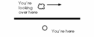
Figure 4. Cartoon showing a left-lateral, or sinistral, fault. You are at the spot marked with a circle, looking at the tree (the blobby thing) on the other side of the fault from you. The fault is represented by the fat black line. Since this is a left-lateral fault, the tree on the other side will appear to you to be moving to the left.
The San Andreas fault is a classic example of a right-lateral strike-slip fault. The Garlock fault, which runs along the northern edge of the Mojave Desert, is a left-lateral strike-slip fault. Big normal faults are found all over the Great Basin. Big reverse faults are found near subduction zones, such as in Alaska.
So how does one recognize a fault au naturel, as it were? If you are just walking around outside looking at the nice rocks and mountains and plants and rivers, how would you know you were looking at a fault?
It turns out you can use basically four methods: biology, geomorphology, geology, and geophysics. In this context, geology refers to looking at rocks, and in particular, noting rocks which are right next to each other and didn't form that way. Geomorphology is the study of the shape of the earth (``geo''=``earth'' and ``morphos''=``shape''), and it refers to using clues like creek beds, scarps, and sag ponds to find faults. Biology in this case means plants and where they grow. Geophysics can mean lots of things, primarily earthquakes, magnetics, and gravity.
One common denominator is that faults tend to be straight lines (more or less). Not much else in nature makes straight lines. If you find a straight line that is natural, it's a good bet you're looking at a fault. Nature abhors straight lines and vacuums...
You can use biology to find faults in certain situations, particularly in arid lands. Often, the rocks in a fault zone can become clayey, and act as a barrier to the flow of groundwater. When this happens, groundwater builds up on the uphill side of a fault, and the water table is raised relative to the other side of the fault. You can sometimes find a long, straight line of palm trees and other vegetation growing in an otherwise basically empty area. This is pretty suspicious and may represent a fault zone. You can find such vegetation lineaments in the desert near Indio, for example.
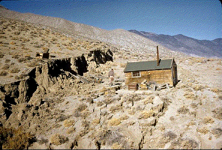
You can use geomorphology to find faults as well. Since faults tend to be straight lines, you look for linear features in the shape of the ground, or features which change abruptly at some straight line. For example, streams which cross active faults can be offset by fault motion over time, and eventually come to have sharp jogs in their courses across the ground. Figure 5 shows a good example of this. Also, linear ponds called ``sag ponds'' form along fault zones, and a chain of these is a good hint of a fault's position. San Andreas Lake (the fault was named for the lake, not vice versa) near San Mateo is a large sag pond dammed to form a reservoir (see Figure 6). Other features which give a clue to the existence of a fault are scarps (see Figure 7), springs, and long, linear valleys.
Figure 5. Wallace Creek on the Carrizo Plain, in central California. Movement along the San Andreas Fault in several earthquakes has offset the two large streams in the center of this image by as much as 130 meters. The San Andreas Fault runs from lower right to upper left through this picture. Image by Fairchild Aerial Photography.
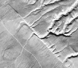
Figure 6. San Andreas Lake, along the San Francisco Peninsula. This is a large sag pond which was dammed to make a reservoir. The fault runs from lower right to upper left in this image. Fairchild Aerial Photography Collection Photo C-6660 31 Dated 23 March 1941.
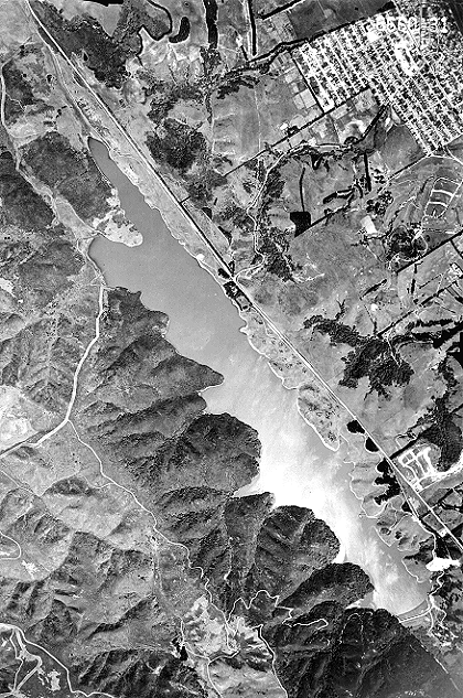
Figure 7. A classic picture of a scarp formed by the 16 December 1954 Dixie Valley earthquake (magnitude 6.8) in Nevada. The miner's shack next to the scarp was relatively undamaged, despite being only a few meters from the two- to three-meter offset. Image by Karl V. Steinbrugge.
Geology can also be used to find faults in the wild. By mapping the location of various rock units, and by noting their characteristic geologies, you may find very similar rock units which are hundreds of miles apart. And you may find rock units which are right next to each other and clearly could not have formed so near to one another. A good example of nearly identical rock units which are widely separated is the Pinnacles Volcanic Formation, which is separated by 315 km along the San Andreas Fault from its ``mate'', the Neenach Volcanic Formation in the Mojave Desert. The Pinnacles are now SE of Salinas in central California, but were once a single unit with the Neenach Formation; these blocks have been separated by movement along the San Andreas fault.
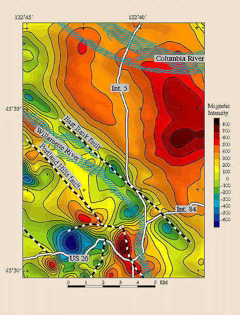
Geophysics can help locate faults as well. In particular, one can plot the locations of earthquakes in a given region over a long period of time and find the currently active faults (since earthquakes happen along active faults). To find faults which only rarely have earthquakes or are no longer active, one can use gravimetry and geomagnetic measurements to find linear features in the gravitational and magnetic fields of the Earth. Figure 8 shows a nice image of the anomalies in the Earth's magnetic field caused by a series of faults near Portland, Oregon.
Figure 8. Map of the intensity of the geomagnetic field near downtown Portland, Oregon. The colors represent the relative intensity of the magnetic field. The dashed lines were drawn to emphasize faults known from previous geologic mapping. Note that there is a strongly linear feature in the geomagnetic anomalies parallel to both the Portland Hills fault and the East Bank fault. Image by Richard J. Blakely, US Geological Survey.
So, to sum up, you find faults in a number of ways, but mostly, you look for straight lines which you can't explain through human intervention.
OK, so all that said, where are the faults in southern California? Basically, the shortest possible answer is: damn near anywhere you look. It will take much to long to explain all of it, and besides, the Southern California Earthquake Center has done a much better job than I ever could on their Faults of Southern California page. Take a gander over there when you can.
Greg Anderson
