OK, so you've listened patiently to me spouting off about one of my personal crusades, and now you're wondering -- what about San Diego?!
The short answer is that, while San Diego is relative safe (seismically, anyway) compared to San Francisco or Los Angeles, it is still in California. And keep in mind that being relatively safe in California is still pretty risky, seismically at least. So while we are safer than much of the rest of the state, we are still at risk for large earthquakes.
3ome of the faults nearby which might have earthquakes which cause damage in San Diego County are:
And I have deliberately left out the biggest single threat to San Diego itself: the Rose Canyon Fault Zone (RCFZ). The RCFZ is active and runs right through downtown, under Lindbergh Field, through Old Town, across the east side of Mission Bay and Pacific Beach, up along Interstate 5, over Ardath Road, and out into La Jolla Bay near the Scripps Institution of Oceanography. The latest information on the fault is that it can generate earthquakes as big as magnitude 7 -- more than big enough to cause severe damage to San Diego proper.
Here's what we now know about the RCFZ, thanks mostly to trenching work done by Dr. Tom Rockwell and his students at San Diego State University (see Figures 9, 10, and 11):
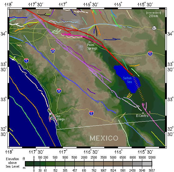
Figure 13 is a nice map I borrowed from the Southern California Earthquake Center. It shows the faults in and near San Diego, and should emphasize further in your mind that San Diego is definitely earthquake country. You can see a nice version of this map, complete with clickable faults which (when you click one) bring up a bit of information on the fault you chose.
Figure 13. Map of San Diego County and surround area, with major known faults shown. Also shown for reference are the major freeways and elevation shading. Map by Southern California Earthquake Center.

San Diego County has had damaging earthquakes in the past, though not as many as some other areas of the state. The biggest earthquakes that we are sure were nearby were in 1862 and 1892, with another big one possible in 1800. The 23 February 1892 earthquake was probably on the Laguna Salada fault, about 125 kilometers east of San Diego, but still caused much damage in San Diego (big cracks in the walls of some buildings, etc.). San Diego also suffered some damage from the 28 June 1992 Landers earthquake, mostly in the form of broken dishes and such and mostly along the beach, where the loose ground amplified the shaking.
There have also been smaller, more recent earthquakes which caused some concern and damage. In 1986, there was a sequence of magnitude 3 and 4 earthquakes just off the coast of Coronado which stirred up a lot of interest and caused a bit of damage. And later in 1986, there was a magnitude 5 earthquake just off Oceanside which caused some damage and was widely felt.
The point of all this is that San Diego has an active earthquake history and is certainly going to have more earthquakes in the future. Obviously, the biggest single risk is the RCFZ, but there are others as well. Further research, including trenching by Tom Rockwell and others and GPS studies by my friend Hadley Johnson and others, will help place more and useful constraints on the dangers facing San Diego.
You might be interested in knowing where you can go to see faults in San Diego. It turns out that there are a couple of nice spots to go to see the Rose Canyon Fault. One of the best places to go is Tecolote Canyon Natural Park, east of Mission Bay. The visitor's center there can direct you to the best exposure of the Rose Canyon fault in the park (it turns out to be just behind the ball fields!). The park has a web page.
Another good spot is the Bayside Trail out on Point Loma. Go to the Cabrillo National Monument Visitor's Center on a nice clear Sunday afternoon. It will cost $4 for a daily permit for one car. The Monument is open from 9 am to 5:15 pm. Bring a picnic lunch -- there are some nice views of San Diego Bay from the trail. You can get a map of the Bayside Trail from the Visitor's Center, and set off on your hike. About a half-mile or so into the hike, you will go around a point and turn left into a canyon. On the far side canyon wall, you should be able to make out a clear fault trace, with offset rock layers. There's also a small cave (really nothing more than an alcove in the wall...) you can poke your head into. Anyway, the trail's nice and a good place for a light hike. I think the total hike is about two miles.
The Cabrillo Monument has a web page.
Greg Anderson