
 |
The current time in San Diego, CA is: 14:07:40 PST, 12/13/25
Latest InSAR, Bathymetry, and Gravity
ALOS-4 Interferogram from GMTSAR: Software and Sample Data - July 29, 2025
Geodesy PhD Program at SIO/IGPP - January 1, 2025
Video - Vertical Gravity Gradient from SWOT - November 1, 2024
Book - Satellite Radar Interferometry: Theory and Practice - May 5, 2025
Instructions to replace the mean sea surface on SWOT data - October 25, 2023
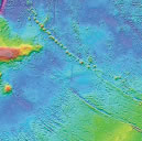
Global synthetic bathymetry V2.0 - August 2, 2023
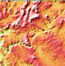
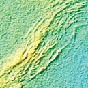
SRTM15+ Global Topography/Bathymetry - New version 2.5, March 20, 2023
Book - Advanced Geodynamics - March 1, 2022
San Andreas Fault System Deformation and Stress Evolution (1600-2022) - April 15, 2022
Video - Deformation along the San Andreas fault system - July 1, 2021
Video - Deep Dive with Margaret Leinen - December 17, 2020
Video - Ridgecrest Earthquake Fractures - October 30, 2020
Podcast - Seeing Plate Tectonics Under the Oceans - October 2, 2020
InSAR time series for the San Andreas Fault - May 1, 2020
GOOGLE VENUS and Subduction on Venus? - May 6, 2016
Global Marine Gravity from CryoSat-2 and Jason-1 - October 2, 2014
HOME |
BACKGROUND |
PEOPLE |
GLOBAL TOPOGRAPHY |
RADAR ALTIMETRY |
SYNTHETIC APERTURE RADAR |
LINKS |
CONTACT
Last modified : 07:56:07 PDT, 07/29/25