
 |
CRUSTAL STRAIN AND TOPOGRAPHY FROM SYNTHETIC APERTURE RADAR INTERFEROMETRY
Current Research Projects
- GMTSAR: An InSAR processing system based on GMT
- InSAR for M7.2 Haiti Earthquake
- InSAR for M7.1 Ridgecrest Earthquake
- 2018 Kilauea eruption and Mw 6.9 Leilani Estates Earthquake
- New Zealand Kaikoura M7.8 earthquake
- Ecuador M7.8 earthquake
- Nepal M7.8 earthquake
- Interseismic deformation of the San Andreas Fault System
- Maule, Chile earthquake
- Wenchuan earthquake
- Kilauea Rift Event, June 17, 2007
- Hector Mine Earthquake
- ALOS InSAR Processing Information
Research Results
- Xu, X., X. Tong, D. T. Sandwell, C. Millner, J. F. Dolan, J. Hollingsworth, S. Leprince, F. Ayoub, Refining the shallow slip deficit - Geophys. J. Int., 203, 48-62, doi: 10.1093/gji/ggv269, 2015.
- An integral method to estimate the moment accumulation rate on the Creeping Section of the San Andreas Fault - Geophys. J. Int., 203, 48-62 doi: 10.1093/gji/ggv269, 2015
- Did Stresses From the Cerro Prieto Geothermal Field Influence the El Mayor-Cucapah Rupture Sequence? - Geophys. Res. Lett., 41, doi:10.1002/ 2014GL061959, 2014
- High-resolution interseismic velocity data along the San Andreas Fault from GPS and InSAR - J. Geophys. Res., 118, doi:10.1029/2012JB009442, 2013.
- Open Radar Interferometry Software for Mapping Surface Deformation - Eos Trans. AGU, 92(28), doi:10.1029/2011EO280002, 2011.
- Estimates of stress drop and crustal tectonic stress from the 27 February 2010 Maule, Chile, earthquake: Implications for fault strength - J. Geophys. Res., v.116, B11401, 13 PP., 2011 doi:10.1029/2011JB008509. Coseismic slip model and stress change model
- The 2010 Maule, Chile earthquake: Downdip rupture limit revealed by space geodesy- Geophys. Res. Lett., v.37, L24311, doi:10.1029/2010GL045805, 2010. supplementary material and Google Earth kmz file and InSAR data points
- Coseismic Slip Model of the 2008 Wenchuan Earthquake Derived From Joint Inversion of InSAR, GPS and Field Data - J. Geophys. Res., v.115, B04314, doi:10.1029/2009JB006625, 2010. InSAR data points and Coseismic slip model
- Optimal Combination of InSAR and GPS for Measuring Interseismic Crustal Deformation - J. Adv. in Space Res. doi:10.1016/j.asr.2010.03.013, 2010.
- Decorrelation of ALOS and ERS interferometry over vegetated areas in California - IEEE Geoscience and Remote Sensing, 10.1109/TGRS.2010.2043442, 2010.
- A Silent M4.8 Slip Event of October 3-6, 1 2006, on the Superstition Hills Fault, Southern California- J. Geophys. Res., v.114, B07402, doi:10.1029/2008JB006135, 2009.
- Accuracy and resolution of ALOS interferometry: Vector deformation maps of the Father's Day Intrusion at Kilauea - IEEE Trans. Geosciences and Remote Sensing, 46, 3524-3534, 2008.
- Coulomb Stress Accumulation Along the San Andreas Fault System
- Radar interferometry for measuring tidal strains across cracks on Europa - J. Geophys. Res., 109, E11003, doi:10.1029/2004JE002276, 2004.
- Accuracy and Resolution of Shuttle Radar Topography Mission Data - Geophys. Res. Lett., 30 (9), doi:10.1029/2002GL016643, 2003.
- Fault creep along the southern San Andreas from InSAR, permanent scatterers, and stacking - J. Geophys. Res., 108 (B1), 2047, doi:10.1029/ 2002JB001831, 2003.
- The 1999 (Mw 7.1) Hector Mine, California Earthquake: Near-Field Postseismic Deformation from ERS Interferometry- BSSA, v.92, no. 4, 1433-1442, May 2002
- Hector Mine Earthquake: Vector Near-Field Displacement from ERS InSAR - BSSA, v.92, no. 4, 1341-1354, May 2002
- Satellite interferometric observations of displacement associated with seasonal ground water in the Los Angeles Basin - , J. Geophys. Res., 107, B4, 2074, 2002.
- Crustal deformation during 6 years spanning the Mw=7.2 1995 Nuweiba earthquake, analyzed by Interferometric Synthetic Aperture Radar - Isr. J. Earth. Scis., 50, 9-22, 2001.
- Topographic phase recovery from stacked ERS interferometry and a low resolution digital elevation model - J. Geophys. Res., 105, B12, 28211-28222, 2000.
- Near-Real-Time Radar Interferometry of the Mw 7.1 Hector Mine Earthquake - GRL, v. 27, p.3101-3104, 2000.
- Phase Gradient Approach to Stacking Interferograms - JGR, v. 103, p. 30183-30204, 1998
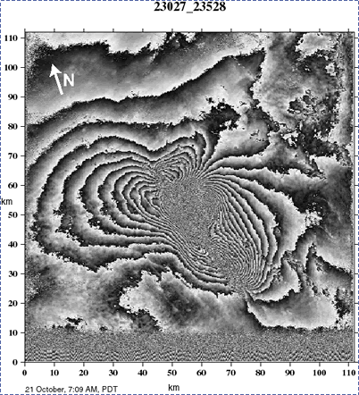 |
| Interferogram of Hector Mine 7.1 M Earthquake. One fringe corresponds to 28 mm of ground displacement away fromt he radar. Synthetic Aperture Radar data are from the European Space Agency Satellite ERS-2 satellite. Data were acquired at Scripps Institution of Oceanography/IGPP on 20 October. Real-Time Orbits were provided by Delft University and the ground station was built by SeaSpace Co. and SIO. |
HOME |
BACKGROUND |
PEOPLE |
GLOBAL TOPOGRAPHY |
RADAR ALTIMETRY |
SYNTHETIC APERTURE RADAR |
LINKS |
CONTACT
Last modified : 12:58:19 PDT, 10/15/21