
 |
SRTM30_PLUS: DATA FUSION OF SRTM LAND TOPOGRAPHY WITH MEASURED AND ESTIMATED SEAFLOOR TOPOGRAPHY
SRTM30_PLUS V1.0 November 11, 2004
LINKS: FTP SRTM30 Land Topography
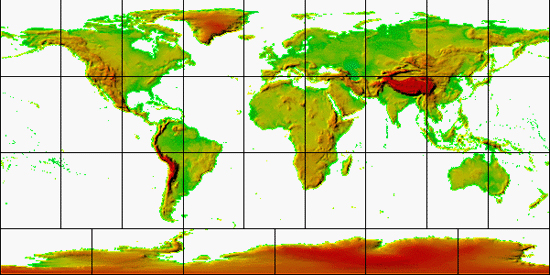
This data consists of 33 files of global topography in the same format as the SRTM30 products distributed by the USGS EROS data center. The grid resolution is 30 minutes which is roughly one kilometer.
Land data are based on the 1-km averages of tropography derived from the USGS SRTM30 gridded DEM data product created with data from the NASA Shuttle Radar Topography Mission . GTOPO30 data are used for high latitudes where SRTM data are not available.
Ocean data are based on the Smith and Sandwell global 2-minute grid between latitudes +/- 72 degrees. Higher resolution grids have been added from the LDEO Ridge Multibeam Synthesis Project and the NGDC Coastal Multibeam Data. Arctic bathymetry is from the International Bathymetric Chart of the Oceans (IBCAO) [Jakobsson et al., 2003].
All data are derived from public domain sources and these data are also in the public domain.
The pixel-registered data are stored in 33 files with names corresponding to the upper left corner of the array shown below.
Quick Contents:
Interactive Maps
The map below has been sectioned into 33 clickable regions. Clicking on a particular region will open a new window showing the zoomed in region in more detail.
© 2004, David T. Sandwell
Related Sites
ALL MARINE BATHYMETRY DATA ARE WELCOME!
If you would like to contribute data to the next version of the global topography grid we would be pleased to use it. Any format is welcome, even raw multibeam formats. For our next version we plan a 1 minute resolution so please do not degrade the resolution of your data set just to make is smaller. If it does not fit into the following anonymous ftp site then send me an e-mail and I'll find another place for it.
ftp topex.ucsd.edu
cd pub/incoming
HOME |
BACKGROUND |
PEOPLE |
GLOBAL TOPOGRAPHY |
RADAR ALTIMETRY |
SYNTHETIC APERTURE RADAR |
LINKS |
CONTACT
Last modified : 12:42:02 PST, 12/10/04